
One platform for a wider campaign
Marine seismic acquisition has traditionally relied on different specialised equipment for different objectives. Exploration, appraisal and 4D surveys typically use large spreads and long streamers towed at depth, while site characterisation surveys use shorter, shallow-towed systems designed to resolve fine detail in the near surface. The distinction has become embedded in survey design, vessel configuration, operational practice and the services offered to the market.
This specialisation limits the ability to combine survey scopes into a broader regional campaign. A vessel equipped for 4D or exploration work cannot normally move directly into site characterisation without changing to application-specific equipment, and a specialist site-survey vessel is not configured to undertake large-scale exploration or reservoir-monitoring surveys. In a market with fewer active seismic vessels and continued pressure on cost and schedule, there is clear value in a platform that can move between these objectives without compromising the data required for any of them.
The 2026 northern European campaign of the Amazon Conqueror demonstrates that this is now possible. Equipped with Isometrix single-sensor, multi-component streamer technology, the vessel moved from a 4D monitor survey to two high-resolution site characterisation surveys, and then to a 3D exploration survey. The same core streamer platform supported each objective, with the spread configuration, recording parameters and operational mode adapted to the individual survey objective.
Extending established 3D and 4D campaigns to site characterisation
Building vessel campaigns that combine 3D exploration and 4D reservoir-monitoring surveys has been established practice for some time. Both applications use broadly comparable deep-towed acquisition platforms, allowing a vessel to move between them through changes to spread configuration and survey design. What is new is the ambition to include site characterisation in the same campaign, extending the use of a single vessel and streamer system into an application traditionally served by specialised campaigns.
The challenge is that site characterisation places greater demands on both spatial and temporal resolution than conventional 3D exploration and 4D reservoir-monitoring surveys. These surveys are often acquired with analogue group-formed streamers at 12.5 m group spacing, which is appropriate for deeper targets but attenuates the high-wave number, high-frequency and steeply dipping signal that is particularly valuable for resolving shallow gas, faulting, channels and other near-surface hazards. Site characterisation therefore benefits greatly from finer spatial sampling and single-sensor recording. It also requires broader temporal bandwidth.
Conventional practice has preserved this bandwidth by towing sources and receivers close to the sea surface, shifting the source and receiver ghost notches to higher frequencies. However, shallow-towed equipment is more exposed to surface-related noise and motion, reducing weather tolerance and increasing weather downtime. Deeper tow improves streamer stability and operational resilience, but brings the receiver ghost notch into the frequency range required for high-resolution imaging. Extending a 3D and 4D campaign to include site characterisation therefore requires both trade-offs to be overcome: preserving the fine spatial detail needed for shallow imaging while retaining the required temporal bandwidth at a tow depth that supports efficient and weather-resilient operations.
Addressing the compromise – preserving detail, recovering bandwidth
Work by Vinje et al. (2025), Redfearn (2025) and Redfearn and Rentsch (2026) provide evidence of how such trade-offs could be addressed technically, to deliver data fit-for-purpose for shallow hazard characterisation. Redfearn (2025), and Redfearn and Rentsch (2026) emphasise the importance of sensor technology and sampling strategy, as opposed to reliance on shallow tow depth.
A suitable system combines single-sensor recording with multi-component measurements. Together, these capabilities address the two technical requirements that have previously separated exploration-class acquisition from high-resolution site characterisation: preserving fine spatial and temporal detail, and recovering bandwidth affected by deeper tow.
Single-sensor recording preserves fine detail
Conventional streamer systems combine multiple sensors through analogue group forming before the data are recorded. Although this reduces data volume and suppresses high-wavenumber noise, the fixed group response also attenuates high-frequency and high-wavenumber signal (see Figure 1a). The effect is particularly important for shallow imaging, where that information contributes directly to the resolution of near-surface events.
In a single-sensor system, each sensor is recorded individually. Data QC preconditioning can therefore be applied at the original sensor spacing ensuring bad samples or sensors do not contribute to the final output. An adequately sampled single sensor system enables separating signal and noise by their characteristics and thus allows for advanced digital filtering (Martin et. al, 2000). As a consequence high-wavenumber and high-frequency signal can be preserved, and the output channel spacing can be selected for the survey objective.
HR data typically require 1ms sampling and UHR data typically require 0.5ms sampling or less (Hill et al., 2024). Consequently, the sample interval further extends the temporal bandwidth needed for both applications and therefore that part of the bandwidth susceptible to attenuation by analogue group-forming. Figures 2 and 3 below illustrate, both in the shot domain and on stacked data, how this affects analogue group-formed data.
Multi-component recording supports deeper tow
The seismic industry has been using multi-component recording to address the bandwidth trade-off associated with tow depth for a long time. The hydrophone and vertical particle-motion measurements have complementary ghost responses. Where the hydrophone response is attenuated around its receiver ghost notch, the vertical component retains information that can contribute through PZ de-ghosting (e.g., Caprioli et al, 2012) and even PZY de-ghosting (Telling and Grion, 2022). Combining the components therefore enables improved recovery of the broadband wavefield compared with hydrophone-only recording.
This is the critical enabler for the wider campaign concept. The streamer can be towed at a depth that improves stability and weather resilience without accepting the bandwidth compromise that would normally limit high-resolution shallow imaging. Dense accelerometer measurements also support an accurate, shot-by-shot estimate of the actual streamer depth profile (see Figure 4), allowing variation from nominal tow depth to be accounted for during de-ghosting and redatuming.
Figure 5 compares single-sensor hydrophone-only, single-sensor PZ and group-formed PZ data. Both single-sensor datasets reveal more detail in the shallow subsurface than the group-formed PZ data, highlighting the information preserved by recording individual sensors. Single-sensor PZ data also provide a better signal to noise ratio than hydrophone-only data, demonstrating the value of multi-component recording.
From technical concept to field validation
A series of field trials was undertaken to test whether deep-towed, single-sensor multi-component acquisition could deliver the resolution required for shallow-hazard work. The trials covered different water depths, tow depths and spread configurations, progressing from a single-streamer system test to configurations representative of 3D site evaluation.
The first trial was acquired in very shallow water with a 2.5km-long streamer towed at 7m depth. In this trial we demonstrated that 1ms multi-component single-sensor recording towed deeper than conventional HR surveys (2m vs. 7m) is able to produce high-resolution images of complex near-surface geology meaningful for shallow hazard interpretation (See Figure 6).
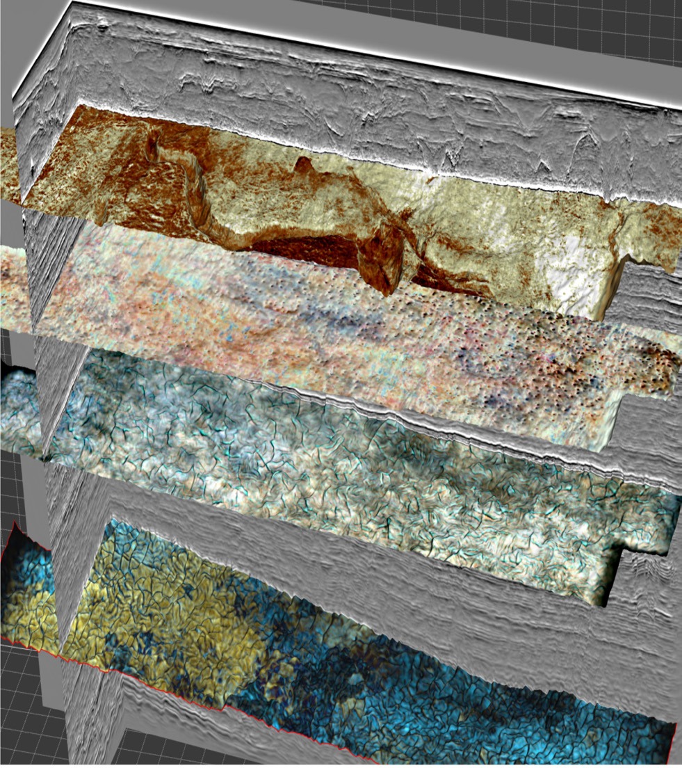
A second trial used an eight-streamer, quad source configuration suitable for carbon capture and storage site evaluation this time towed at 8 m (Redfern et al, 2026). The results shown in Figure 7 underscored the observations from the first trial that the single sensor multi-component streamer normally used for larger-scale 3D and 4D acquisition projects can deliver the high-resolution imaging required for CCS, particularly in the shallow subsurface, while simultaneously sustaining reliable imaging at the reservoir depths. The combination of 1ms data, a zero-offset towing configuration and single-sensor, multi-component recording resolves glacial geomorphology for geohazard screening ahead of drilling, captures bright soft amplitude anomalies and associated pockmarks that indicate gas migration and potential seal retention issues, and permits imaging of polygonal fault networks at reservoir-relevant levels to inform connectivity and compartmentalisation assessments.
A third trial was designed as a validation study against an existing underlying site survey and used a compact, high-density spread towed at 8 m in both fair weather and sea states above 3.5 m. The data clearly showed a distinct high-resolution character, imaging impedance contrasts within the glacially influenced Quaternary section, a possible seabed discontinuity extending into the underlying unit, well-defined glacial erosion between approximately 460 and 510 ms, and deeper scour-dominated units from about 610 to 720 ms (Figure 8). The validation against the underlying shallow tow site survey data demonstrated that the deep-towed single-sensor multi-component spread delivered meaningful shallow hazard imaging. The study also demonstrated robust data quality even in sea states exceeding 3.5m resulting from the deep 8m tow which represents a significant operational advantage for site survey conditions.
Together, the three trials established the technical basis for using the same streamer platform beyond its established exploration, appraisal and 4D applications. They showed that high-resolution shallow imaging depends not only on tow depth, but on the combination of sensor architecture, multi-component measurements, fine temporal sampling, accurate depth estimation and broadband processing. In an additional development, as well as the newly-established capability to record hydrophone and accelerometer data at 1 ms sample interval, system capacity proved adequate to support acquisition of Hydrophone data at 0.125 mssample interval, completing both HR and UHR requirements.
From validation to a multi-objective campaign
The Amazon Conqueror campaign translated this capability into an operational sequence, as shown in Figure 9. The vessel began the 2026 northern European season with a 4D monitor survey over the Mariner field in the UK North Sea. The same acquisition technology had already been used for earlier monitor surveys over the field, supporting repeatable time-lapse acquisition for reservoir monitoring and field-management decisions.
The changes between configurations during the campaign are summarised below.
| 4D monitor | 3D HR/UHR1 | 3D HR/UHR2 | MC Exp. 3D |
Streamers | ||||
# | 8 | 8 | 8 | 12 |
Separation | 75 m | 25 m | 25 m | 112.5 m |
Length | 3100 m | 1200 m | 1200 m | 10000 m |
Depth | 18 m | 8 m | 8 m | 18 m |
Sources | ||||
# | 1 | 4 | 4 | 3 |
Volume | 5085cuin | 270cuin | 270cuin | 3390cuin |
Table 1. Summary of campaign in-water equipment configurations. Source: The Norwegian Offshore Directorate’s website.
The vessel then moved approximately 100 km southeast to the Norwegian Continental Shelf and changed survey mode. Using the same streamer technology with the newly enabled sampling capability, it acquired two site characterisation projects of approximately 96 km² and 60 km². Each survey was designed to deliver 3D HR and 3D UHR datasets in a single acquisition pass, with data suitable for geohazard identification and well planning.
After completing the site characterisation work, the Amazon Conqueror continued to the Norwegian Sea for a 3D multi-client exploration survey, returning to a large-spread exploration configuration. The sequence — 4D reservoir monitoring, HR/UHR site characterisation and 3D exploration — demonstrated that the vessel could move between distinct market applications while retaining the same core acquisition technology.
The wider value of one adaptable platform
The significance of the campaign is not simply that an exploration-class vessel can acquire a site survey. It is that one acquisition platform can deliver fit-for-purpose data across exploration, reservoir monitoring and site characterisation without requiring separate specialist streamer systems for each objective. The vessel configuration and survey design can change, but the multi-component single-sensor streamer remains the common technical foundation.
This flexibility creates the opportunity to plan wider regional campaigns around a sequence of client and subsurface objectives rather than around the limitations of specialised equipment. It can improve vessel utilisation, reduce the need to mobilise separate platforms, and make more effective use of constrained seismic fleet capacity. For site characterisation, the productivity and weather resilience of a deeper-towed spread, optionally with a bigger footprint than the established norm for this survey type, also make larger regional programmes more practical, providing broader geological context for hazard assessment, well placement, trajectory planning and field-development decisions.
Conclusion
The 2026 Amazon Conqueror programme demonstrates a practical model for multi-objective seismic acquisition. Single-sensor recording preserves the fine spatial and temporal information required for high-resolution work, while multi-component measurements support recovery of the bandwidth normally affected by deeper tow. This allows the operational advantages of towing deeper to be realised without compromising the data requirements of site characterisation.
With that constraint removed, the same streamer platform can support 4D monitoring, HR and UHR site characterisation, and 3D exploration. The campaign therefore moves the multi-objective concept beyond technical validation: it shows that one vessel, equipped with one adaptable acquisition system, can serve a wider programme of subsurface objectives.
References
- Caprioli, P.B.A., Özdemir, A.K., Özbek, A., Kragh, J.E., van Manen, D.J., Christie, P.A.F. and Robertsson, J.O.A. [2012]. Combination of Multi-component Streamer Pressure and Vertical Particle Velocity – Theory and Application to Data. 74th EAGE Annual Conference & Exhibition, Extended Abstracts.
- Hill, A.W., Nicol, G. and Cook, M.R. [2024]. A proposed standard for seismic frequency nomenclature for geophysical site investigation surveys in the offshore energy sector. First Break, 42(11), p. 37-41.
- Martin, J., Ozbek, A., Combee, L., Lunde, N., Bittleston, S. and Kragh, E. [2000]. Acquisition of marine point receiver seismic data with a towed streamer: 70th SEG Ann. Internat. Mtg., Expanded Abstracts, 37-40.
- Redfearn, S. [2025]. Single sensor and 1ms recording for improved imaging in the shallow subsurface. 86th EAGE Annual Conference & Exhibition, Extended Abstracts.
- Rentsch, S., Redfearn, S. and Bull-Jansen, S. [2026]. Challenging the Status Quo: DeepTow Multicomponent Acquisition for Shallow Geohazards. 5th EAGE Marine Acquisition Workshop, Extended Abstracts.
- Rentsch, S., Redfearn, S., Widigdo, F., Bull-Jansen, S., Sundvor, E. and Basset, J. [2026]. High Resolution Shallow Hazard Characterization with Multicomponent Single-Sensor Streamers Towed Deep - A Validation Study. 87th EAGE Annual Conference &Exhibition, Extended Abstracts.
- Redfearn, S. and Rentsch, S. [2026]. Resolving the Shallow: Benefits of Multicomponent and Single-Sensor Streamers. 5th EAGE Marine Acquisition Workshop, Extended Abstracts.
- Redfearn, S., Rentsch, S., Bull-Jansen, S. and Martin, J. [2026]. Evaluating a new CCS survey design option – a North Sea case study. 87th EAGE Annual Conference & Exhibition, Extended Abstracts.
- Telling, R. and Grion, S. [2022]. Multicomponent De-Ghosting Using a Hybrid Operator in Frequency and Space. 83rd EAGE Annual Conference & Exhibition, Extended Abstracts.
- Vinje, V., Josse, F., Choquer, T., Zhao, P., Thauvin, I., Charron, P. and Herrmann, P. [2025]. Ultra highresolution shallow marine imaging with a sparker over a deep streamer. First Break, 43(8), p. 39-45.

