
Introduction
Initially conceived as a hybrid streamer-OBN operation, a challenging business environment and crew availability necessitated splitting the project into two separate surveys – with the towed streamer portion recorded in Q1 2025 and the OBN recorded in Q4 2025. In this paper we provide an overview of the survey design and acquisition of the OBN portion, which represents the first use of OBN technology over the Jubilee and TEN oilfields, and the first application of the technology offshore Ghana. Figure 1 shows the regional setting of these oilfields in the Tano Basin, approximately 60 km offshore Ghana.
Geological setting and exploration success
The Jubilee field was discovered in 2007 by the Mahogany-1 well and confirmed as a world class multi-billion barrel field by the follow-up Hyedua-1 appraisal well in the same year. The reservoirs are stratigraphically stacked Turonian turbidite sandstone fan lobes. Subsequent exploration successes (2009-2011) in the western portion of the block confirmed the presence of the TEN field complex: an acronym for the individual Tweneboa, Enyenra and Ntomme fields. Production started in Jubilee in 2010 and in TEN in 2016.
For a thorough description of the geological setting of the Tano Basin and the Jubilee and TEN oilfields the reader is directed to Dailly et al 2012, and Cronin et al 2022.
Complex near surface and the move to multi-azimuth acquisition
A total of six narrow azimuth (NAZ) streamer surveys have been shot over the fields between 2007 and 2025. 4D seismic has added considerably to the subsurface understanding and is a vital tool in reservoir management. Table 1 presents a summary of the streamer acquisition configurations used to date.
Year | Field | Azimuth | Streamers | Source | Comments |
2007 | Jubilee | North-South, single NAZ. | 8 x 75m x 6000m @ 6m depth | 2 x 3147 cu in @ 5m depth, | In general feather is significantly higher for North-South oriented surveys as it isperpendicular to the prevailing East-West Guinea current. Feather is reduced at deeper tow levels. |
2013 | Jubilee | East-West, single NAZ. | 12 x 75m x 7050m @ 9m depth, fan to 100m at tail. | 2 x 3147 cu in @ 7m depth, | |
2014 | TEN | East-West & North-South, Dual NAZ. | 12 x 75m x 7050m @ 12m depth, fan to 100m at tail. | 2 x 4439 cu in @ 8m depth, | |
2017 | Jubilee | East-West & North-South, Dual NAZ. | 12 x 75m x 7050m @ 20m depth, fan to 100m at tail. | 2 x 3150 cu in @ 7m depth, | |
2019 | TEN | East-West & North-South, Dual NAZ. | 12 x 75m x 6000m @ 12m depth, fan to 100m at tail. (some NS sequences @ 20m depth). | 2 x 4450 cu in @ 8m depth, | |
2025 | Jubilee & Ntomme | East-West, single NAZ. | 12 x 75m x 7050m @ 9m depth, fan to 100m at tail. | 2 x 3350 cu in @ 7m depth, eSource |
Table 1. Towed-streamer acquisition parameters over Jubilee and TEN 2007-2025 showing a transition from single to dual azimuth NAZ surveys. The 2025 NAZ survey preceded the OBN survey to be discussed here. All streamer surveys used dual source (separation 37.5 m, shot point interval 18.75 m).
The first 4D baseline streamer survey over Jubilee was acquired in 2007 as a single azimuth, NAZ towed streamer survey, oriented approximately north-south and parallel to the intense modern-day canyon system which defines such deepwater marine slope settings. Figures 1 & 2 show the modern-day channelling as expressed on the bathymetry map, and the paleo canyons as expressed on the shallow seismic section and the velocity model.
The shooting direction for the 2007 survey was dictated by a requirement to minimise the impact of the present day and paleo-canyon systems on the underlying processed image. Consequently, the survey was acquired perpendicular to the Guinea current which resulted in observed feather angles of more than 10 degrees, and a very high infill rate.
Shooting parallel to the present seafloor and paleo-canyon system led to flatter gathers but a strong structural imprint of pull-ups and push-downs was imparted to the deeper image by this complex overburden.
A second NAZ baseline survey shot approximately east-west was acquired over Jubilee in 2013 and as expected had lower but variable feather with consequently lower infill. While acquisition across the trend of the complex overburden undershoots the short wavelength velocity anomalies and consequently reduces the structural imprints/distortions compared to that observed on the north-south data, it unfortunately produces more complex gathers (Jones 2012, O’Brien et al 2017). In general, gather moveouts are complex and the AVO response through the Turonian reservoirs exhibits Class II and IIp behaviour, highlighting the importance of correct imaging. As illustrated in Figure 2a, the wavefield is further complicated by the presence of other deeper velocity anomalies (heterogeneous fans) which overlie and are in proximity to the uppermost reservoir unit.
Forward modelling had previously been used extensively to illustrate the challenges in subsurface illumination and data complexity and is presented in O’Brien et al, 2017. Increased understanding of the impact of the overburden complexity on the deeper reservoir-level imaging and data quality, led to dual azimuth surveys being acquired over Jubilee in 2017, and over TEN in 2014 and 2019. As expected, the north-south oriented surveys have lower 4D repeatability due to the predominant, yet variable east-west Guinea current.
Whilst the case for an omni-azimuth, long-offset, full wavefield OBN dataset was made through modelling almost a decade ago (O’Brien et al 2017), the resulting tender exercise simply highlighted the significant cost disparity between the towed-streamer NAZ survey and the OBN method at that time. For comparison the most attractive option for the small OBN survey (with a receiver patch of 100 km2 and a shot apron of 10 km) would have cost over 3 times that of a towed streamer NAZ survey delivering 2000 km2 of data. In 2017 a cost factor of 60 on a per sq km basis (approximately the cost of a well) outweighed potential geophysical benefits. With the maturing of OBN technology, improved survey efficiency and cost reduction, the technology is now offered competitively. This OBN survey was initially designed to provide an updated velocity model for imaging the legacy 4D streamer.
Initial single field survey design for budget/tender purposes
Initially the new seismic program considered the hybrid case of 4D NAZ towed-streamer combined with OBN, but whilst attractive on paper, this option was ruled out early in the planning as it became apparent that the project would be delayed awaiting the OBN element. This delay was considered incompatible with the requirements of the planned drilling program – as evidenced in Table 1 the lapse time over Jubilee at the time of planning (2022) was five years, hence an updated 4D towed-streamer dataset became a time critical priority over the more complete OBN dataset. Consequently, a single azimuth east-west NAZ 4D towed-streamer survey was recorded over Jubilee and Ntomme in Q1 2025.
For a smaller operator adopting a new technology, establishing a robust budget and evaluating the tender required input from experienced third-party specialists. The initial OBN survey design used the Jubilee 2013 towed-streamer east-west source positions and orientation, decimating to a potentially coarsely sampled 412.5 m node grid which was examined for fold and potential repeatability (Figure 3). Initial modeling was conducted over Jubilee only.
Published information (Olofsson et al, 2012; Dellinger et al, 2017; Mei et al, 2019) has shown that in a deepwater setting such as this we could tolerate relatively sparse nodes to meet the velocity model-building goal of the OBN survey. This preliminary acquisition configuration of sparse nodes was used for budget estimation before a formal tender was issued. Key parameters required for establishing budget quotations were image area, node spacing, shot carpet grid and crossline offset. The crossline offset was examined using diving wave depth of penetration analysis as shown in Figure 4. Longer offsets record deeper penetrating diving waves and lead to more accurate velocity model determination via Full Waveform Inversion model-building techniques. The study considered the varying water depth over the fields and in particular the imaging challenges beneath the deeper water to the west where the overburden is more complex. Figure 4 confirms the increased depth of penetration from greater offsets, with reduced improvement at offsets greater than 15 km. Therefore, the minimum crossline offset was set at 15 km. Operationally, as discussed later in the paper, we were able to achieve crossline offsets of more than 25 km in some parts of the survey.
Post-tender survey optimisation
The tender process confirmed that a greater number of nodes were available within budget, and this allowed additional objectives to be incorporated into the survey design. Extensive testing and further survey optimisation were undertaken in close cooperation with the acquisition contractor. The survey was extended from the firm Jubilee only case, to include the TEN fields, hitherto considered optional. The secondary objectives were expanded to include reflectivity imaging through optimal use of the denser node distribution and shot carpet, while remaining within budget, together with an initial assessment of 4D OBN-on-streamer data over core areas of both fields.
An azimuthally invariant 2656 cu. in. source was proposed during bid submission, which compared favourably to the legacy 3147 cu. in. source with improved azimuthal response (Figure 5). This allows shooting in the most economical orientation without compromise (i.e., ability to change shooting orientation). Unfortunately, an ultra-low frequency seismic source was not available.
Experience from the 4D streamer surveys had shown that shooting east-west parallel to the prevailing Guinea current was compromised by changes in vessel speed making repeatability difficult. However, when shooting north-south, sea currents cause a variable source array skew. Ultimately, for the OBN, source lines were chosen with a slight rotation to 18 degrees to better match the legacy north-south streamer source grid. A triple source array resulting in 50 m by 100 m source sampling was chosen over the full survey area, with interleaved shooting over the core of both the Jubilee and Ntomme field areas to yield a 50 m by 50 m shot carpet. During processing we discovered source skew caused an azimuthal effect on the bubble pulse of the signature and full 3D directional debubble and designature were required. For future monitor surveys we believe the Guinea sea-current regime will allow the source skew to be matched.
2D and 3D full waveform modelling was used to verify the earlier diving wave analysis used for crossline offset determination. Synthetic data was also used to model and determine the final nodal spacing, grid layout and evaluate the consequences of node failure. In summary, the survey optimisation phase allowed deployment of available nodes on a finer 337.5 m / 675 m hexagonal grid rather than the planned square 412.5 m / 825 m grid. This is detailed in Figure 6.
A comparison of the initial and final acquisition parameters is presented in Table 2.
Parameter | Original | Optimised | Comments |
Source Type | 3147 cu. in. match to streamer | 2656 cu. in. OBN source | Directionally invariant, eSource. Ultra-Low Frequency not available. |
Source Sampling | 56.25 x 100m source grid | 50 x 100m source grid 50 x 50m source grid on core of Jubilee, Ntomme & Enyenra South | Increased source density Better 4D match and reflectivity, square bins. Additional interleaved shot lines over key areas. |
Shot Line Orientation | 108 or 288 degrees | 18 degrees | Better matching to streamer surveys for processing. |
Shooting Method | Shooting on location | Shooting on average | Tests undertaken on eastern edge of survey confirmed original plan would be difficult to achieve. |
Nodal Sampling | 2008 stations @ 412.5 / 825m Regular grid | 2245 stations @ 337.5 / 675m Hexagonal grid | Increased node count, greater node density for similar survey duration. Improved near offset sampling. |
Crossline Offset | 15km | 15km | Minimum offset achieved, some parts have longer offsets ~25km. |
Operational | Single nodes | Double node | Balance of protection against node failure vs deployment / retrieval rate. |
Table 2. A comparison of the initial (tendered) and optimised acquisition parameters used in the OBN survey.
Enhanced quality control
The survey design was vetted by two independent external experts and the on-board third-party QC team selected had extensive OBN acquisition experience and independent QC tools. Extensive equipment checks and audits were performed prior to vessel and equipment acceptance and on the two seismic vessels quality control was handled by a strong team consisting of two geophysicists, two EHS specialists and two navigation experts including a 4D specialist. Since a large fraction of nodes are not picked up until the last shot is fired, verifying data quality is a key issue at both a technical and contractual level. We availed of the required pre-survey in-field gain-test to conduct a ‘first-line’ QC to verify the performance of the systems onboard both vessels (Figure 7).
Ten nodes were deployed for the gain test, recording data from the full source array in a test line replicating the streamer survey orientation and including a well tie. The test was extended to acquire offsets to 15 km, and the resulting data was assessed by the acquisition contractor, the supervisory (offshore and onshore) team, and the processing contractor to verify the data quality.
During the survey enhanced onboard processing QC was employed to provide clean data to a separate processing contractor. The use of a common processing software package by the acquisition contractor and the operator enabled rapid and advanced QC at the operator’s office. A fast-track FWI was also performed in a combination of offshore and onshore processing (Winters et al, 2026) by the acquisition contractor which provided useful information for the operator to bring to the full-integrity processing and model-building being conducted by a separate contractor.
Node data must be downloaded and approved for acceptance before demobilisation is completed. A high number of adjacent failed nodes would require costly additional node layout and reshooting. The acquisition contractor was able to lay two nodes at each receiver station without adding to the node deployment time (a further densification of the nodal patch would have impacted the budget). In practice there were no failed stations and very few individual nodes failed.
Acquisition performance and program evolution
The fleet consisted of one dedicated node-handling vessel and one dedicated seismic source vessel. These were accompanied by four guard/support vessels with additional support from a dedicated Ghana Navy vessel. This complement of guard/support vessel has been used with great success on recent towed-streamer surveys over these fields.
The survey was conducted with open and transparent reporting by the entire fleet leading to strong EHS performance. A workshop-based pre-survey engagement with stakeholders, supported by Ghana authorities, led to minimal fishing interference, and enhancement of local content and knowledge transfer.
The shot repeatability metrics were high throughout the survey, supporting the use of the survey as a baseline. All nodes were positioned within a contractual limit of +-10 m with the vast majority within +-3 m. Contractor first-break-based positioning was verified onboard with third-party software, with strong agreement. Eight PIES instruments were also deployed across the survey area, four of which reoccupied locations from the earlier streamer survey.
The final survey configuration differed from the pre-plot due to several factors summarised in Figure 8. These important changes, some of which were enacted mid-survey, are outlined further below:
- During nodal layout to the east of Jubilee additional source lines were added moving eastward away from the survey area. Acquisition of these lines commenced although the crossline offset did not meet the contractual 15 km minimum offset, these lines were ultimately instrumental in determining the forward shooting plan. At the outset the intent was to shoot on location, but our experience in the area indicated that the currents could be challenging, and this was proven to be the case. This early experience of working with the source array in these currents allowed extended tests and comparisons leading to a change of shooting to average mode for the rest of the survey. Without this change the survey would have progressed more slowly with an impact on the budget.
- The retrieval of the first laid nodes in both Jubilee and TEN was delayed to allow the capture of longer offset data, even though the source vessel was operating beyond the contractual minimum crossline offset. No extra survey time was added to acquire these extra offsets.
- Normally, after the last preplot shot is fired, the source vessel remains on contract, idle, and cannot depart until all collected nodes have verifiable data. In this survey, once node retrieval commenced in eastern TEN the spare time was used to shoot additional dense shot lines to the west.
Early pre-survey engagement with the in-field operations teams (one each at the Jubilee and TEN FPSOs) was essential, and close-passes near both FPSOs were refined in the field through the co-operation of all concerned. The presence of a drillship led to one nodal station being omitted and the missed shots due to vessel close pass restrictions were later infilled resulting in complete shot coverage in this area. Dense interleaved shots over Jubilee and extended offset trial sail lines were part of the original plan. An additional patch of dense nodes and associated interleaved shots were included over TEN through judicious use of vessel time.
Permission to cross the international border to operate within Côte d’Ivoire was granted mid-survey but with a time window which restricted our ability to shoot the planned program there. In the days leading up to the receipt of approval the survey orientation was changed at the western end to become parallel to the international border (as in the instance of non-approval source lines would then extend the full length of the planned survey). This re-orientation led to a small shot-line overlap, and the restricted time-window to operate across the border resulted in some dropped shot lines (see figure 8).
These changes were possible due to the flexibility of the acquisition contractor who allowed us to optimise vessel usage, enabling added value whilst protecting the budget. No weather downtime occurred, and fishing-related interruptions were limited. The project thus minimised the downtime when vessels were inactive – the additional nodes (over and above the contractual number) were deployed without disruption to the plan / budget, and importantly whilst the node recovery was ongoing the source vessel remained active infilling additional shot lines. Even if the later shot lines had reduced offset, they nonetheless represent valuable data.
In summary, the flexibility of the acquisition contractor and the close working relationship allowed extra source lines to be acquired for several mid-survey program changes which resulted in more data for no additional cost.
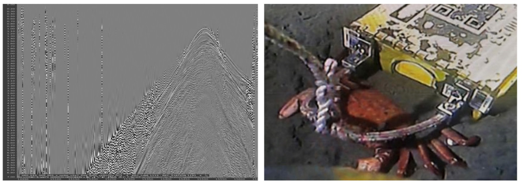
The full-integrity data processing continues, hence this paper focuses on survey-design and acquisition outcomes rather than image uplift. One curious type of noise burst was identified on the vertical geophone but not pressure components, and were attributed to passing crustaceans as seen in Figure 9.
Conclusions
We have described the planning, design and implementation of a deepwater OBN survey, the first offshore Ghana, West Africa. Pre-survey refinement of the source along with an increase in node inventory led to a better sampled dataset. This was further improved upon during survey execution through a flexible, collaborative approach to vessel usage allowing survey optimisation. The survey was executed safely, on time and within budget. The resulting long offset, full-azimuth dataset provides a substantially improved basis for velocity model building and future reservoir imaging across Jubilee and TEN, while the acquisition experience demonstrates that complex deepwater OBN can be delivered efficiently by a smaller operator through rigorous modelling, independent QC and adaptive survey execution.
Acknowledgements
We thank Tullow, Kosmos Energy, GNPC Explorco, Ghana National Petroleum Corporation, and PetroSA Ghana for their support and insightful discussions.
We thank our technology partners; Tetra Tech for acquisition planning support (providing Figure 3), Shearwater Geoservices for its commitment to delivering high-quality data in a safe and efficient manner and TGS for its dedication and focus on the processing of these datasets. The close collaboration with Shearwater Geoservices survey planning team, before and during the survey, went a long way to optimising the survey and hence maximising value.
References
- Cronin, B.T. and the Jubilee Team, Tullow Ghana Limited. [2022]. Giant pockmark-initiated deep-water slope channel complexes. AAPG Bulletin, 106(4), 829-868. DOI: 10.1306/11042118179.
- Dailly, P., Henderson, T., Hudgens, E., Kanschat, K. and Lowry, P. [2012] Exploration for Cretaceous stratigraphic traps in the Gulf of Guinea, West Africa and the discovery of the Jubilee Field: a play opening discovery in the Tano Basin, Offshore Ghana. Geological Society, London, Special Publications, 369, 235-248. DOI: 10.1144/SP369.12.
- Dellinger, J., Brenders, A.J., Sandschaper, J.R., Regone, C., Etgen, J., Ahmed, I. and Lee, K.J. [2017] The Garden Banks model experience. The Leading Edge, 36, 151-158. DOI: 10.1190/tle36020151.1
- Jones, I.F. [2012] Tutorial: Incorporating near-surface velocity anomalies in pre-stack depth migration models. First Break, 30(3), p. 47-58.
- Mei J., Zhang, Z., Lin, F., Huang, R., Wang, P. and Mifflin, C. [2019] Sparse nodes for velocity: Learnings from Atlantis OBN full-waveform test. 89th SEG Annual International Meeting, Expanded Abstracts, 167-171. DOI: 10.1190/segam2019-3215208.1
- O’Brien, G.S., Igoe, M., Doherty, J., Mahob, P. and Mecklenburgh, R. [2017] Offshore imaging with complex overburden: understanding gather complexity and resulting attribute accuracy through synthetics. The Leading Edge, 36, 159-165. DOI: 10.1190/tle36020159.1
- Olofsson, B., Mitchell, P. and Doychev, R. [2012] Decimation test on an ocean-bottom node survey: Feasibility to acquire sparse but full-azimuth data. The Leading Edge, 31, 457-464. DOI: 10.1190/tle31040457.1
- Winters, S., Earnshaw, T., Garrigan, L., Bartlett, R., Staddon, M., Igoe, M., Doherty, J. and Hardy, R. [2026] FWI-Enabled OBN Ultra Fast-track; A Ghana Case Study. First EAGE/SBGf Workshop on Seismic Processing, Extended Abstracts. DOI: 10.3997/22144609.202682028

