
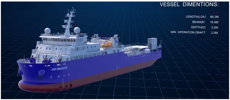
Recent developments in marine seismic acquisition are driven by the need to improve 4D responsiveness, reduce operational footprint, and enhance imaging resolution in increasingly complex environments. This paper suggests an integrated approach combining Ocean Bottom Node (OBN) hybrid acquisition, an On-Demand 4D monitoring philosophy, quad-source design, and resilient positioning strategies under GNSS constraints. Field implementations in Middle East shallow waters demonstrate that targeted 4D acquisition using a hybrid vessel significantly reduces costs, turnaround time, and environmental exposure, while maintaining high data quality. In parallel, quad-source configurations could unlock substantial improvements in shot-point density and high-frequency content without compromising operational efficiency. Finally, mitigation strategies against GNSS outages are discussed, highlighting the critical importance of multi-constellation GNSS receivers and alternative optical positioning technologies. The combination of these innovations represent a step change towards a more agile, efficient, and resilient marine seismic acquisition paradigm.
Introduction
Marine seismic acquisition has undergone significant transformation over the past decade, driven above all by the widespread adoption of Ocean Bottom Node (OBN) technology. In congested or shallow-water settings, where conventional streamer operations are constrained or impractical, OBN systems offer superior illumination, wide-azimuth coverage, full four-component recording, and the geometric freedom to tailor receiver layouts to complex reservoir architectures. These attributes have made OBN solutions increasingly attractive for both initial 3D imaging and repeat 4D monitoring of producing fields.
However, conventional OBN acquisition strategies remain constrained by structural inefficiencies. A typical 4D campaign requires multiple dedicated vessels, covers areas of 200-800 km² or more, demands mobilisation cycles of four to five months, and triggers a new commercial tender for each survey. In an industry where reservoir management decisions cannot wait for extended processing timelines, this model is misaligned with the realities of modern field development. Cost volatility, market cyclicality, high greenhouse gas emissions, and elevated offshore personnel exposure compound these operational constraints.
Simultaneously, two less-discussed limitations have constrained acquisition quality. On the source side, conventional dual-source geometries impose bin sizes no smaller than 12.5 m, restricting high-frequency content and vertical resolution relative to what is routinely achieved onshore. On the positioning side, the increasing frequency of GNSS disruptions, driven by geopolitical interference targeting GPS L1/L2 frequencies, has exposed a critical vulnerability in marine seismic operations, threatening positioning integrity and operational continuity.
This paper suggests a unified framework addressing all four limitations through complementary innovations developed and field-tested on a large offshore carbonate field in Qatar during 2023 and 2024:
- An On-Demand 4D monitoring strategy that targets specific reservoir areas aligned with drilling, production and injection schedules, replacing costly full-field surveys with focused, high-value acquisition patches.
- An OBN hybrid vessel concept enabling a single dynamically positioned vessel to alternate between node handling and source acquisition roles, dramatically simplifying logistics, reducing cost and guaranteeing excellent vessel occupational rate.
- A quad-source geometry (for 3D purposes) that, through the interfacing of dual gun controllers with an advanced internal navigation system, achieves bin sizes of 8 m × 6.25 m and shot-point densities of ~5,000 SP/km² — representing single-digit bin sizes in a marine environment.
- Resilient positioning strategies — including multi-constellation GNSS receivers and optical laser-based source positioning — designed to maintain survey productivity during GNSS outage events.
Together, these innovations constitute a step change in the agility, resolution, and robustness of marine seismic acquisition, with particular relevance to mature offshore fields in shallow, congested, and geopolitically sensitive environments.
Conventional OBN acquisition: Limitations and operational constraints
To appreciate the significance of the innovations described in this paper, it is necessary first to characterise the operational model that they replace. Conventional 4D OBN acquisition in the Middle East context has historically required:
- A minimum fleet of four vessels: one Node Handling Vessel (NHV), one source vessel, one support/chase vessel, and one additional chase vessel.
- Mobilisation costs of $7-15 million per survey, with preparation cycles (non-objection letters, marine unit acceptance, preplots, vessel rigging) of four to five months.
- Survey areas of no less than 800 km², driven by fleet economics rather than reservoir monitoring needs.
- Day rates of $230,000-350,000, Marine Gas Oil (MGO) consumption of 20-40 m³/day, and more than 100 personnel on board.
- A new competitive tender process for each 4D monitor, with a commercial lead time exceeding 12 months.
This model generates several systemic inefficiencies. Vessel utilisation rates are inherently low when surveys are designed around minimum economic area thresholds rather than reservoir demand. Mobilisation and demobilisation costs represent a disproportionate fraction of survey expenditure. Furthermore, the processing of full-field OBN datasets in complex carbonate environments, involving nodal displacements (usually due to fishing interferences), multi-component demultiple, inversion and time-lapse differencing, can consume several months, creating a significant lag between acquisition and the delivery of actionable 4D intelligence to subsurface teams.
From a resolution standpoint, conventional dual-source configurations, operating at source line intervals of 50 m (25m COS) with flip-flop shooting, are limited to bin sizes of 12.5 m or larger (Table 1).
Source Grid | No. of Sources | Resulting Bin Size | SP Density / SLI |
Sparse (50m × 50m) | 2 | 25m × 25m | 400 SP/km² 100m SLI |
Mid-Sparse (37.5m × 37.5m) | 2 | 18.75m × 18.75m | 711 SP/km² 75m SLI |
Dense (25m × 25m) | 2 | 12.5m × 12.5m | 1,600 SP/km² 50m SLI |
Quad Source (16m x 12.5m) | 4 | 8m × 6.25m | 5,000 SP/km² 50m SLI |
Table 1. Conventional and quad-source source grid configurations with resulting bin sizes and SP density. SLI: Sailed Line Interval. Quad-source values correspond to the field trial described in Section 5 while Dense source values correspond to our 4D baseline grid.
This constrains the recoverable high-frequency content and vertical resolution of the dataset, particularly in shallow carbonate reservoirs where thin-layer discrimination is critical. The contrast with onshore acquisition, where five-metre bin sizes are now routine, is striking.
On-Demand 4D monitoring: A philosophy shift
The On-Demand concept represents a fundamental rethinking of how 4D seismic programmes are structured. Rather than acquiring periodic full-field surveys on a fixed schedule, the On-Demand approach identifies the specific reservoir polygons where measurable 4D signal is anticipated, and sequences acquisition to match the pace of field development activity, such as drilling campaigns, workover programmes and injection pattern expansions.
From full-field to targeted acquisition
Analysis of reservoir dynamics on the Qatar field indicated that meaningful 4D signal was consistently expected over areas of 140-180 km² per year, which is a fraction of the 800 km² demanded by a conventional fleet-economic model. By designing annual acquisition campaigns around targeted polygons, the On-Demand philosophy eliminates the acquisition of areas where no significant signal is anticipated, compressing both mileage and processing load simultaneously.
Each monitoring polygon is co-designed by the geosciences, reservoir engineering, and operations teams. Polygon boundaries reflect the spatial extent of predicted pressure and saturation changes, informed by production history, well trajectories, and simulation outputs. This integration ensures that 4D acquisition delivers intelligence directly relevant to pending field development decisions, such as infill well location, conformance management, or injection strategy revision.
Processing turnaround benefits
A frequently underappreciated consequence of full-field acquisition is the processing time it imposes. In a multi-reservoir carbonate setting, the 4D processing workflow (encompassing noise attenuation, demultiple, binning, pre-stack depth migration, post-migration conditioning, and 4D inversion to separate stacked reservoir responses) is computationally demanding and scale dependent. Full-field datasets require months of processing before usable 4D attributes are available to subsurface teams.
By restricting each campaign to 140-180 km², the On-Demand approach reduces processing volumes by an order of magnitude relative to a full-field survey, enabling first-pass 4D images to be delivered on timescales compatible with active reservoir management. Time-shift attributes and impedance change volumes from the first two monitors demonstrated strong correlation with well data and production history, validating the approach.
Field results
The two monitors acquired in 2023 and 2024 cover the first deployment of OBN 4D technology on this giant carbonate field using the hybrid approach. Results have been encouraging. Time-shift (ΔTWT) attributes show robust and stable signal on reservoir difference volumes, clearly resolved when viewed in conjunction with conventional amplitude anomalies. In the stacked multi-reservoir context, 4D inversion proved essential: by differentiating acoustic impedance volumes (ΔAI/AI) between the 2019 OBN baseline and the monitor acquisitions, it is possible to isolate the 4D response of individual reservoirs, a task impossible with amplitude-only analysis.
Valid 4D signal is consistently aligned with well trajectories and coherent with production history. Reservoir heterogeneities identified from signal distribution along well paths have been integrated into pattern reviews and reservoir model calibration. The 4D data is now routinely used to identify conformance issues, assess completion integrity, and evaluate the reliability of dynamic models. The acquisition approach indeed enables dynamic adjustment of survey priorities in response to evolving reservoir behaviour or operational constraints.
OBN hybrid vessel concept and field implementation
Concept and operational principle
The hybrid vessel concept is the operational enabler of On-Demand 4D acquisition. A hybrid vessel is a single dynamically positioned (DP-2) vessel capable of alternating between two distinct operational modes: Node Handling Vessel (NHV) mode, in which nodes are deployed or recovered from the seabed, and source mode, in which the vessel tows and fires seismic sources while nodes remain on the seabed recording. The same vessel provided by the contractor, serves both functions on this project. It is a purpose-built OBN hybrid platform with more than 72 tons of onboard compressors and six available source beam slots, four of which are currently rigged.
This configuration eliminates the multi-vessel spreads required in conventional OBN operations. Where a standard campaign involves a minimum of three to five vessels operating simultaneously, the hybrid model requires at most two vessels (the hybrid NHV/Source itself plus a support/chase vessel). The operational implications are substantial.
Comparative performance and economics
Table 2 presents a direct comparison between the conventional OBN approach and the hybrid model, based on data from the Qatar field campaigns. The cost reduction is striking – mobilisation expenditure falls from $7-15 million to $2.7-3.5 million, while day rates drop from the range of $230,000-350,000 to $150,000–160,000. Personnel on board decreases from more than 100 to approximately 60. MGO consumption falls from 20-40 m³/day to less than 12 m³/day.
Parameter | Conventional OBN | OBN Hybrid |
Personnel on board | 100+ people | ~60 people |
Number of vessels | 3 to 5 | 2 |
Mobilisation cost (M USD) | 7 – 12 | 2.7 – 3.5 |
Day rate (K USD/day) | 230 – 350 | 150 – 160 |
MGO consumption (m³/day) | 20 – 40 | < 12 |
C&P process duration | > 12 months | 5-year framework |
CO₂ savings (5-year period) | — | 49,435 tons avoided |
Table 2. Operational and economic comparison between conventional OBN and OBN hybrid vessel approaches. Data from the Qatar field implementation (2023–2024). CO2 savings estimated over a five-year contractual period versus equivalent conventional operations.
Over a five-year contractual framework, a structural innovation that eliminates repeated tendering and the associated 12-month commercial lead time, the hybrid approach is estimated to avoid approximately 49,435 tonnes of CO2-equivalent emissions relative to conventional operations. Importantly, productivity is maintained as the hybrid vessel achieves around 8160 shot points per day in source mode, and approximately 500 nodes per day in node handling mode, figures comparable to those achieved during the 2019 full-fleet OBN baseline (8011 SP average per day and 430 nodes moved per day).
SIMOPS simplification and HSE benefits
Beyond the direct economic advantages, the hybrid model substantially simplifies Simultaneous Operations (SIMOPS) management. In a congested field environment with more than 800 producing wells and continuous drilling and workover activity, coordinating the positioning and movement of three to five seismic vessels is a significant logistical and safety challenge. Reducing the active vessel count to one or two materially decreases collision risk, simplifies exclusion zone management, and reduces the administrative burden of SIMOPS approvals.
The reduction in offshore personnel from 100+ to approximately 60 people correspondingly reduces HSE exposure in terms of both man-hours at sea and the consequences of any incident. For an operator committed to reducing offshore risk, this is a significant non-economic benefit of the hybrid approach.
The five-year contractual framework further enhances operational continuity. New vessels, new contractors, and renegotiated terms at each survey cycle introduce variability in node technology, crew competency, and operational procedures, are all complications to 4D repeatability. The multi-year hybrid model enhances crew familiarity and execution consistency. Reduced vessel interfaces streamline communication and improve overall operational efficiency that is essential for time-lapse data quality.
Quad-source design: Unlocking resolution in OBN acquisition
The resolution gap in OBN source design
While the OBN receiver side has benefited from sustained innovation (with improved node autonomy, sensor sensitivity, deployment productivity and OBN acoustic positioning), source design for OBN acquisition has remained comparatively conservative. In stark contrast to onshore acquisition, where five-metre bin sizes are achievable through dense source arrays, and to streamer acquisition where multi-source configurations have been commercially deployed for several years, the OBN industry has largely remained bound to dual-source geometries producing bin sizes of 12.5 m or larger.
Two principal constraints explain this conservatism. The first is mechanical: achieving short shot point intervals at commercial vessel speeds requires high-pressure (HP) compressor capacity and rapid air refill cycles. Many OBN source vessels, particularly those operating in shallow or transition zone (TZ) environments where reduced draft limits loading capacity, carry only one to four sub-arrays and modest HP installations.
The second constraint is electronic: conventional gun controllers carry minimum cycle times of 2000–3600 ms between successive shots, which, at realistic vessel speeds, imposes a lower bound on inline bin size that precludes single-digit values in multi-source configurations (see Table 2 of the original equipment data).
A further consideration is source volume. OBN geometry, unlike streamer geometry, recovers a far greater fraction of the acoustic energy emitted by a shot. In streamer acquisition, only approximately 15% of source energy is recorded by receivers towed behind the vessel; in OBN, the full spherical wavefield (including up-going energy reflected off the sea surface, i.e. the ghost) is recorded at the seabed. This fundamentally different illumination geometry means that the large source volumes developed for streamer applications are unnecessary for OBN, and that reduced-volume sources can be deployed without compromising signal-to-noise ratio.
The quad-source concept
Motivated by these observations, and inspired by the progressive adoption of quad-, penta-, and hexa-source configurations in the streamer industry over the preceding decade, a quad-source design was developed for 3D purposes and tested on board the hybrid vessel in Middle East shallow waters. The concept centres on three innovations deployed simultaneously.
First, the dual gun controller interface: the contractor’s in-house Integrated Navigation System (INS) was interfaced with two independent gun controllers, reducing the minimum shot-to-shot cycle time from the range of 2000–3600 ms typical of conventional single-controller set-ups to approximately 2100 ms. With SPI equal to vessel speed multiplied by cycle time, and IL bin size scaling as SPI × 1 (dual), SPI × 1.5 (triple), and SPI × 2 (quad), this cycle time reduction is what makes an 8-9 m inline bin size achievable in quad mode at commercially viable vessel speeds. Table 3 illustrates the achievable bin sizes across the operational speed range.
Vessel Speed (ABS) | Speed (m/s) | SPI (m) | IL Bin – Dual | IL Bin – Triple | IL Bin – Quad |
3.9 kn | 1.99 | 4.0 | 4.0 m | 6.0 m | 8.0 m |
4.0 kn | 2.04 | 4.1 | 4.1 m | 6.1 m | 8.2 m |
4.2 kn | 2.14 | 4.3 | 4.3 m | 6.5 m | 8.6 m |
4.4 kn | 2.24 | 4.5 | 4.5 m | 6.7 m | 9.0 m |
4.6 kn | 2.35 | 4.7 | 4.7 m | 7.0 m | 9.4 m |
Table 3. Inline bin size achievable with dual gun controller (2100 ms cycle time) as a function of vessel speed and source configuration. Cycle time: ~2100 ms (dual gun controller). SPI = vessel speed × cycle time. IL bin size: Dual = SPI × 1, Triple = SPI × 1.5, Quad = SPI × 2. No current assumed; Average Bottom Speed (ABS) maintained above 3.8 knots for steerability. Highlighted row (4.4 kn) corresponds to the field trial operating conditions.
Second, the four arrays configuration: leveraging the hybrid vessel capacity, four independent 600 cuin arrays are deployed, with each array corresponding to half of the source Baseline (1200 cuin, made of 2 x 600 cuin arrays). Each 600 cuin array is perfectly symmetrical in both inline and crossline directions, providing excellent omnidirectionality. The sailed line interval (SLI) is maintained at 50 m, preserving survey duration relative to a conventional dual-source campaign, while the centre-of-source separation (COS) of 12.5 m in the crossline direction yields a resulting crossline bin size of 6.25 m.
Third, dithered firing: a ±48 ms dithering time was introduced to the firing sequence to facilitate simultaneous source separation during processing. This is essential for isolating individual source contributions from the blended wavefield recorded at the nodes and is a prerequisite for achieving the full SP density benefit of the quad configuration.
Field implementation and results
The quad-source trial was conducted over 44,960 shot points, representing a sufficiently large dataset to evaluate both the practical operability of the configuration and its imaging benefits relative to conventional dual-source acquisition processed from the same receiver geometry.
The target shot point interval in the inline direction was 3.125 m (flip-flop-flap-flup firing at 2100 ms with an ABS of approximately 4.4 knots), yielding the design 8 m × 6.25 m bin size. In practice, a mean SPI of approximately 4 m was achieved, corresponding to a realised inline bin size of approximately 8 m (marginally larger than the theoretical 6.25 m target) reflecting the operational constraint of maintaining ABS above 3.8 knots. This remains a single-digit value and represents a factor-of-1.5 improvement over the 12.5 m bin size of a conventional dense dual-source design.
Shot point density increased from 1600 SP/km² in the conventional dense dual-source scenario to approximately 5000 SP/km² (a factor of three improvement) with negligible impact on survey duration at the same SLI. Increased shot density improves migration stability in targeted complex velocity regimes.
Spectral analysis of the processed data reveals significant improvements in high-frequency content. Normalised spectra extracted from crossline sections show a consistent gain of +10 to +20 dB in the 60-95 Hz frequency band relative to equivalent dual-source data processed through the same sequence (deblending, denoise, demultiple, regularisation, pre-stack depth migration, and post-migration conditioning). Crossline and inline section comparisons confirm markedly improved vertical resolution, particularly in the shallow target interval (0-480 ms TWT).
Near Field Hydrophone (NFH) attribute comparisons between dual and quad source data further demonstrate the imaging benefit: the reduced source volume eliminates sensor clipping issues that affected the dual-source configuration, improving the reliability of near-surface source signature monitoring. Crucially, no detrimental effect from the reduced source volume was observed in the target bandwidth; the full spherical OBN recording geometry compensates effectively for the smaller source output.
The primary limitation identified in the trial relates to the legacy gun controller technology: the single gun controller available at the start of the trial was able to generate only one passive NFH (Near Field Hydrophone) record per shot, instead of recording all three passive NFH as originally intended. Thus, reducing the effective near-field source sampling density. Notwithstanding this constraint, quad-source NFH outputs demonstrated better lateral continuity and improved definition of subsea and near-seabed structures relative to the dual-source equivalent, which is a direct consequence of the substantially higher shot-point density, as illustrated by the time slice comparison in Figure 6. Modern dual gun controller configurations (have since been targeted for upgrade) can produce three NFH signals per shot, significantly improving this ratio. Additionally, quad-source shot point positioning, while operationally acceptable for 3D applications, was identified as marginally exceeding the tight repeatability tolerances required for 4D time-lapse acquisition. This remains an active area of development.
GNSS Outages: A Growing Risk and Mitigation Strategies
Context and operational impact
Reliable positioning is a prerequisite for marine seismic acquisition. Every shot point must be located with sub-metre accuracy; node deployment positions must be known to within a few metres; and in 4D applications, source repeatability tolerances impose particularly stringent positioning requirements, since deviations between base and monitor shot positions degrade the time-lapse signal through non-repeatable geometries. Any disruption to positioning systems therefore has direct consequences for data quality and operational productivity.
GNSS outages, caused by intentional interference targeting GPS L1/L2 carrier-phase signals, have become an increasing operational reality in the Middle East and other geopolitically sensitive regions. These events can last from a few minutes to several consecutive days and have been observed to affect multiple vessels simultaneously. The consequences include loss of vessel Dynamic Positioning (DP) reference, degraded source shot-point positioning, and complete operational standby until signal recovery.
The impact is asymmetric across the systems on board a seismic vessel. As Table 4 illustrates, the two principal positioning systems (i.e., the marine DP bridge system and the seismic acquisition positioning system) are configured differently in terms of constellation diversity, with markedly different vulnerability profiles.
System Category | Equipment / Solution | Constellations Used |
Seismic DGNSS (Primary) | APEX PRO / Auto | GPS, GLONASS, BeiDou, Galileo |
Seismic DGNSS (Secondary) | APEX / Auto | GPS, GLONASS, BeiDou, Galileo |
Source rGPS | SeaMap Buoylink 4DX | GPS, GLONASS only |
Marine DP Bridge (vessel) | FURUNO / KODEN / FUGRO | GPS (L1/L2 mostly) — most vulnerable |
Table 4. GNSS positioning systems observed on the BGP Innovator during the Qatar survey, with constellation coverage and relative vulnerability to L1 interference. Marine DP bridge systems (Furono, Koden, Fugro) operate exclusively on GPS L1 which is the frequency most targeted by jamming events. Seismic DGNSS receivers (APEX PRO/APEX) are configured for all four constellations, providing significantly greater resilience.
Multi-constellation GNSS: The first line of defence
The contractual specification of multi-constellation DGNSS receivers for the seismic positioning system proved to be the single most effective mitigation in maintaining acquisition continuity during observed outage events. By configuring the primary (APEX PRO) and secondary (APEX) receivers to use all four constellations (GPS, GLONASS, BeiDou, and Galileo), the seismic crew could access signals on frequency bands less affected by the jamming events. In particular, BeiDou B2a (1,176.45 MHz) and B2b (1,207.14 MHz) signals, together with Galileo E5a/b, were significantly less impacted than GPS and GLONASS signals during observed outage events, providing sufficient satellite geometry to maintain a reliable DGNSS solution.
Critically, this solution allowed node handling operations, where source positioning is not required, to continue throughout GNSS outage periods. The NHV’s DP system, anchored to the GPS L1 signal via the standard marine bridge receivers (Furono, Koden, Fugro), was the first to lose reliable positioning during outages. Contractor being also the hybrid vessel owner was able to implement the derived navigation department positioning solution into the bridge console when those latter faced disruption. Additional workarounds including local radar references and manual heading corrections were employed to maintain safe station-keeping during these periods, though these techniques are not a substitute for reliable GNSS for precision manoeuvring.
Optical source positioning
The critical vulnerability exposed by multi-constellation GNSS is the source relative GPS (rGPS) system. The SeaMap Buoylink 4DX pods used for source positioning are compatible only with GPS and GLONASS signals and cannot access BeiDou or Galileo. During outage events that affect GPS and GLONASS simultaneously (which is common, as both operate at frequencies within the targeted band), source shot point positioning becomes unreliable or impossible using conventional rGPS.
To address this gap, a new optical pulsed laser system, developed by BGPO, was installed onboard the hybrid vessel and integrated within BGPO’s Integrated Navigation System (INS). Minor adjustments within INS interface allowed this optical pulsed solution to run in parallel with the rGPS workflow, generating S01 navigation files simultaneously from both systems. This parallel operation means the backup system is always active and calibrated; it does not need to be switched on reactively when an outage occurs. This new optical pulsed solution does not need to have prisms being installed, which makes the installation set-up relatively easy.
Comparison between rGPS and BGPO proposed solution outputs during the test, that was conducted over 50,877 shot points on both straight and deviated acquisition lines, demonstrated reliable and accurate agreement in inline shot positioning. The crossline component is well-controlled on straight lines; some deviation was observed on highly deviated source lines, consistent with the geometric constraints of the optical ranging system. Overall, the BGPO solution provides a viable independent positioning measurement capable of sustaining source acquisition through GNSS outage events. Combining satellite, optical, and procedural solutions reduces single-point failure risk.
Fixed layback: A last-resort fallback
A simpler fallback, tested during the outage simulation, is the use of a fixed layback assumption, i.e., substituting a fixed estimated distance between the vessel Navigation Reference Point (NRP) and the source array mid-point for the time-varying rGPS-derived position. While inline positioning errors under this approach are manageable (the source vessel travels a predictable path along the shot line), crossline deviations from planned pre-plot positions grow rapidly when the vessel is crabbing, that is, steaming at an angle relative to its heading to compensate for crosscurrent. At crabbing angles surpassing approximately 7°, the postplot positions deviate sufficiently from the preplot to exceed 4D positioning tolerances, rendering this approach unsuitable for time-lapse acquisition.
Additionally, the fixed layback approach is sensitive to sea state: as conditions deteriorate, crabbing angles increase and vessel heading variability grows, further degrading crossline positioning accuracy. For 3D acquisition where positioning tolerances are more relaxed, fixed layback may represent an acceptable temporary workaround; for 4D operations, it should not be considered a reliable strategy.
Integration and Synergies: Toward a fully optimised acquisition ecosystem
The four innovations described in this paper are individually significant; their combination produces an acquisition system whose capabilities exceed the sum of its parts. Figure 9 illustrates conceptually how the four components interact and reinforce one another within an integrated campaign framework.
On-Demand targeting reduces the survey footprint and compresses processing timelines. The hybrid vessel concept is the operational vehicle that makes targeted, patch-based acquisition economically viable and logistically manageable. Quad-source design enhances the resolution and frequency content of each patch, ensuring that the data quality justifies the acquisition investment. Resilient positioning strategies ensure that the whole system continues to function during GNSS outage events, which, in the Middle East context, can no longer be treated as exceptional occurrences.
The economic synergy is equally important. The cost reductions enabled by hybrid operations (roughly a 60% reduction in mobilisation cost and a 50% reduction in day rate relative to conventional approaches) create budget headroom to increase acquisition frequency. Rather than a single large survey every five years, the On-Demand model enables targeted campaigns annually, aligned with the reservoir management cycle. Crucially, the 5-year contractual framework eliminates the twelve-month commercial preparation cycle for each survey, meaning that acquisition can in principle be initiated within weeks of a reservoir management decision.
The quad-source capability is particularly well-suited to the hybrid operational model. Because the hybrid vessel can transition from node handling to source mode and back, quad-source patches can be deployed on targeted areas with minimal additional logistics. The maintenance of the 50-m SLI in quad-source mode ensures that survey duration is not increased relative to dual-source acquisition at the same sailed line density, making the resolution improvement cost-neutral in terms of vessel time.
Remaining challenges and future directions
While the field implementations described here demonstrate the viability and value of each innovation, several challenges remain and are the subject of ongoing development.
In quad-source positioning, the shot point positioning achieved during the trial, while acceptable for 3D imaging, marginally exceeds the tight repeatability requirements for 4D time-lapse acquisition in some operational conditions. This is being addressed through refinements to the source rigging geometry, optimisation of the dithering scheme, and improvements to the BGPO INS source tracking algorithm. Meeting 4D positioning tolerances with quad-source geometry would unlock the full potential of this configuration for time-lapse applications.
Gun controller technology represents a second area requiring upgrade. The legacy single-gun controller configuration available at the start of the trial limited NFH generation to one per four shot points. Modern dual gun controllers, which are now being targeted for deployment on board hybrid vessel , are capable of generating three NFH signals per shot, substantially improving the near-surface attribute quality that is critical for shallow carbonate characterisation.
GNSS resilience, while significantly improved by multi-constellation receivers and optical pulse-based solution, remains an evolving challenge as the nature of interference events changes. The rGPS pods (SeaMap Buoylink 4DX) used for source positioning remain restricted to GPS and GLONASS, representing the remaining vulnerability in the positioning chain. Industry-level progress toward multi-constellation rGPS pods would close this gap. In the interim, BGPO alternative provides an effective operational bridge.
However, source positioning is not the only GPS dependency in OBN acquisition. A vulnerability that has received insufficient industry attention is the pervasive reliance on GPS-derived timestamps for two fundamental functions: shot point firing triggers, and node clock synchronisation during pre-dive and post-recovery operations. With the exception of very few available nodes, which have been upgraded/designed to support nodal synchronisation through timestamps signals other than GPS ones, virtually all OBN node systems currently available on the market depend on stable GPS timestamps to maintain clock discipline throughout their deployment cycle. During a GNSS outage, nodes that cannot acquire a reliable GPS time reference before diving, or after recovery, accumulate clock drift that cannot be corrected in processing, thus potentially compromising the integrity of the seismic data entirely. The same dependency affects shot firing: source vessels relying on GPS pulse-per-second signals for trigger timing face degraded shot synchronisation during outage events. These are not marginal risks in the current geopolitical environment, but they represent a systemic exposure for the entire OBN industry. Finding robust, GPS-independent solutions for both node clock synchronisation and shot firing triggers must be elevated to an urgent industry priority and should be a key specification requirement in future node technology development programmes.
Beyond incremental improvements to conventional GNSS redundancy, the industry should look toward emerging quantum sensor technologies as a longer-term path to full GNSS-denial resilience. Quantum inertial navigation systems exploit quantum mechanical properties of matter to measure acceleration and rotation with extraordinary precision, enabling autonomous positioning without any dependency on external satellite signals. Adapting such systems for subsea/surface offshore environment, represents a compelling avenue. It would fundamentally eliminate the vulnerability threatening OBN operations continuity during interference events. The transition from GNSS-dependent to GNSS-denial-resilient acquisition should be established as a strategic objective for the OBN industry.
Extension of the hybrid acquisition model to deepwater environments, over small mileage (< 600 km² using very sparse node grid), is a natural next step. While the current implementation is optimised for the shallow-water Middle East context, where reduced vessel draft and SIMOPS complexity strongly favour a single-vessel approach, the fundamental economics of hybrid operations (reduced fleet size, multi-year contracting, patch-based targeting) are applicable in deeper settings. Adaptation of the node handling and source rigging systems to deepwater constraints is required.
Finally, continued workflow development is needed to further compress the 4D processing turnaround. Advances in artificial intelligence-assisted noise attenuation, rapid inversion, and automated 4D quality control offer a path toward near-real-time 4D delivery: a goal that is now plausible given the acquisition footprint reductions achieved by On-Demand/Hybrid approaches and this shifts 4D seismic toward a routine, decision-driven asset management tool.
Conclusions
This paper has presented a unified framework for agile, high-resolution, and resilient marine seismic acquisition, combining four complementary innovations field-tested on a giant offshore carbonate field in Qatar during 2023–2024. The following conclusions are drawn:
- The On-Demand 4D philosophy, targeting 140–180 km² of focused acquisition per year and aligned with drilling and reservoir management schedules, delivers actionable 4D intelligence faster and at significantly lower cost than conventional full-field monitoring strategies. Integration with subsurface workflows has already enabled identification of reservoir heterogeneities, conformance issues, and model calibration opportunities.
- The OBN hybrid vessel concept reduces mobilisation costs by approximately 65–70%, day rates by approximately 50%, MGO consumption by more than 60%, and offshore personnel by approximately 40% relative to conventional multi-vessel OBN operations. Over a five-year campaign, these reductions correspond to an estimated avoidance of 49,435 tonnes of CO2-equivalent emissions. Productivity is maintained at levels comparable to conventional fleet operations.
- Quad-source design, enabled by dual gun controller interfaced within BGPO’s INS, achieves a bin size of 8 m × 6.25 m and shot-point densities of approximately 5,000 SP/km², thus representing single-digit bin sizes in a marine OBN environment for the first time. Spectral improvements of +10 to +20 dB in the 60–95 Hz band, improved vertical resolution in section comparisons, and enhanced NFH outputs confirm the imaging value of the configuration.
- The multi-constellation compatible GNSS approach (GPS, GLONASS, BeiDou, Galileo) effectively mitigate vessel positioning vulnerability during L1/L2 interference events, maintaining node handling operations throughout outage periods. New optical-pulsed laser positioning solution provides a reliable independent backup for source positioning that cannot yet access BeiDou or Galileo frequencies via conventional rGPS pods.
- The integration of these four innovations creates mutually reinforcing synergies: cost reductions enable greater acquisition frequency; targeted patches facilitate quad-source deployment; and resilient positioning ensures the whole system operates continuously in challenging environments.
Together, these advances define a new operational paradigm for marine seismic acquisition: one that is faster, cheaper, safer, more environmentally responsible, and higher in resolution than the conventional model it replaces. The experience from the Middle East demonstrates that this paradigm is not merely conceptual: it is operational.
Acknowledgements
The authors gratefully acknowledge the contributions of all field crews, seismic processing teams, and subsurface specialists involved in the Qatar acquisition campaigns. Special thanks are due to the North Oil Company (NOC), QatarEnergy, TotalEnergies Qatar and BGP operational and management teams for their support of the field trial and data release for publication.
References
- Berthereau, G. [2021] 4D Sensitivity to Dynamic Properties on a Carbonate Field: an Insight into 4D Monitoring Strategy. 82nd EAGE Annual Conference & Exhibition, Extended Abstracts.
- BGP. [2023] BGP INNOVATOR — Technical Specifications and OBN Hybrid Operational Performance Summary. Internal technical document.
- Ellabad, Y., Achilli, F., Lamerain, O., Al-Naimi, A.R.A., Xu, Z., Wolfarth, S. and Pan, J. [2024] Quad Source in Middle East Shallow Waters Context. EAGE Seabed Acquisition Workshop, Extended Abstracts.
- Lamerain, O., Achilli, F., Berthereau, G., Walker, C. and Du, H. [2024] Innovative 4D Strategy Combining OBN Hybrid Vessel and On-Demand Philosophy. EAGE Seabed Acquisition Workshop, Extended Abstracts.
- Lamerain, O., Zumbiehl, R., Pethe, P. and Pan, J. [2024] GNSS Outages and How to Tentatively Reduce Their Impact on Seismic Survey Acquisitions. TotalEnergies / North Oil Company / BGP internal technical report, V4.

