
Joeri Brackenhoff, Paula Rulff, Jinqiang Chen, Arend-Jan Krooneman, Yosua Adisapta Pranata Andoko and Arno Freeke discuss a ground penetrating radar scenario using their newly developed GeoProVE educational tool.
Abstract
GeoProVE (Geo-Processes Virtual Education) is a tool designed to improve geophysics education by creating interactive virtual reality environments where students can digitally experience how physical measurements interact with the subsurface. Traditional geophysics education is limited in how these measurements are visualised and relies on schematic drawings and simulations with low interactivity. By integrating digitalisation technology in the form of virtual reality with simulations of geophysical processes, we aim to enable students to experience geophysical data acquisition in immersive ways that will greatly enhance the learning experience. In this article, we will discuss a Ground Penetrating Radar scenario in GeoProVE.
Introduction
Our world is undeniably becoming more digital, and this ongoing transformation has led to increasing interest in the development of innovative digital methods for teaching and learning in geoscience, such as interactive digital textbooks, 3D caves or virtual reality (VR) experiences (Chenrai & Jitmahantakul, 2019; Lyu & Wang, 2024; Tovar, Jonker, & Hürst, 2020). While VR technology was originally mainly used for entertainment purposes, such as movies and video games, it also holds great potential for education. The interactive and immersive nature of the technology is the reason. VR users are experiencing situations they never could before. This includes the ability to go to places one cannot physically travel to, or the ability to see processes that are not visible to the naked eye. These places and processes can be located in the subsurface, which makes the VR technology very relevant for geoscience education.
The field of geophysics is a prime target for the use of VR education: While geophysical measurements are usually made at the surface of the Earth, most of the actual physical interactions occur in the subsurface. Furthermore, most geophysical methods are based on acoustic, elastic or electromagnetic wavefields, which cannot be directly sensed by the human eye. This can make it hard for people who are new to the field of geophysics to understand how the physical processes in the subsurface lead to the recorded data. While there exist excellent textbooks and a wealth of online information, students often struggle to connect the abstract physical concepts to the practical measurements. This highlights a clear gap and the need for more effective educational approaches.
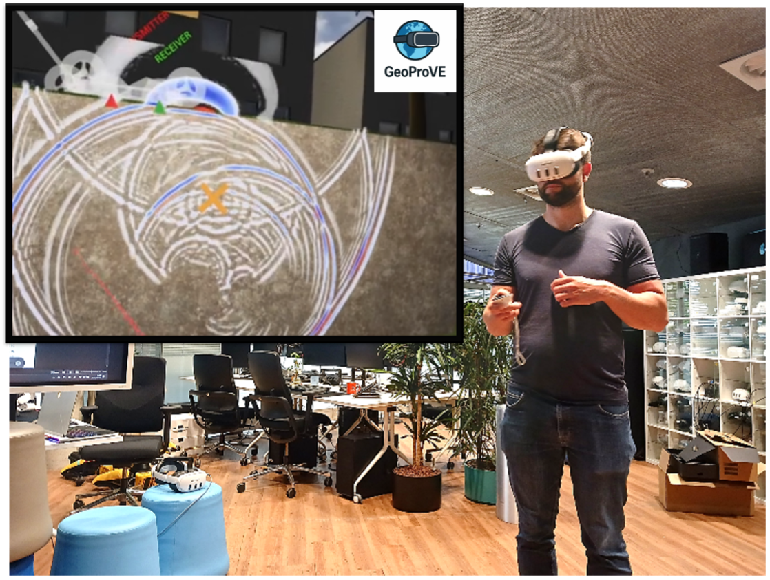
To combat this gap, we developed the GeoProVE tool, which stands for Geoscience Processes Virtual Education. It is a VR tool designed to strengthen the connection between the theoretical basis and practical applications in geoscience education. We started the development with a scenario to explain the principle and field application of Ground Penetrating Radar (GPR) for pipe detection in the subsurface (Figure 1). We chose GPR because it is an Applied Geophysics method taught in geophysics as well as civil engineering educational programmes, and it is comparatively straightforward to implement, because it is typically applied at the metre scale, employs a single portable measurement device, and is often acquired along 2D lines. In the GPR scenario, we include challenge-based learning methods (Gallagher & Savage, 2023) to help users learn about GPR in a fun and interactive way. Hence, textual explanations are purposefully kept to a minimum and newly introduced phenomena are first observed in virtually acquired data and then explained to users. This approach is complemented by multiple-choice questions and simple objectives that make use of the VR controls. The aim is to create an interactive environment in which students experience the sensation of performing fieldwork, supported by additional interactions that clearly and engagingly visualise the geophysical surveying concept.
In this article, we will discuss how the GPR scenario was developed. First, we will review the development process, including some of the critical hardware and software utilised to create the VR environment. Then, we will discuss some of the critical design choices that were made in explaining and visualising the GPR method. Additionally, we will present some of the outreach activities for which we used GeoProVE.

