
Background
Building damage induced by land subsidence is currently a hot-topic in the Netherlands. This topic raised attention since this area became affected by climate change related periods of prolonged spring and summer droughts. Because large parts of the country consists of a soggy river and coastal subsurface, these droughts result in a rapid volumetric loss of shallow soft soil by strong decreasing water content. As a consequence, numerous reports of building damage spawned in recent years, instigating societal awareness of this topic and ample media coverage. The driving mechanism behind this is the shrinkage of surficial clay and peat beds during drought, and their subsequent swelling when rewetting in autumn. These shrink-swell cycles can exert strong forces on buildings, especially when structures have shallow foundations directly on these surficial soil beds. When these soil movements give rise to uneven settlements, buildings may deform and ultimately lead to structural damage. This happens when a building is partially situated on soft soil, and partially on stiff soil like sand, causing tilting of structures. A recent prognoses stated that it is expected that foundation related damage in the Netherlands, often caused by land subsidence, will be around 54 billion Euro’s the coming decades (RLI, 2024). However, long-term monitoring timeseries, crucial to understand building responses to soil deformation, are at the moment lacking in the Netherlands.
Approach
To investigate the processes of land subsidence and building deformation in various settings, we installed monitoring sites in two different parts of the coastal plain (Figure 1). The first site was installed in autumn 2024, and is situated in the northern coastal plain (Ezinge, Groningen province). The coastal sequence here is fully dominated by tidal processes. The uppermost clay bed in this area is deposited in salt marshes, where suspended clay particles came in contact with brackish water, changing its mineral composition, thereby providing it with strong shrink-swell behavior (Veenenbos and Schuylenborgh, 1951). The second site was installed in spring 2026 (Ridderkerk, Zuid-Holland province); this site is located at the intersection zone between fluvial and tidally dominated processes, resulting in a coastal matrix of peat and clay dissected by sandy channels. By focusing on sites that are either characterized by a uniform strongly deforming clay bed or by a heterogeneous subsurface, we aim to collect information from various settings.
We use high-precision extensometers (< micrometer) for monitoring soil deformation, custom designed for our experiments (Becerra Silva et al., 2026). The extensometers consist of separate anchor modules, allowing placement of one unit along a wall or around a building. Per site, three extensometer anchors were deployed at depth, monitoring soil movement between the anchors and the surface (Figure 2). Prior to installment, a geological site investigation was executed with Cone Penetration Testing (CPT). CPT comprises the pushing of a cone with constant rate (2 cm/sec) into the subsurface, during which the resistance the cone experiences during penetration is logged; soft soil provides minimal resistance, whereas sand provides higher resistance. With this information, the depth of the extensometer wells and that of the piezometers was determined. The extensometers and piezometers were placed using hydraulic push drilling (conducted by Wiertsema & Partners); besides wells to install equipment, this method also yielded undisturbed samples which were logged in the field.
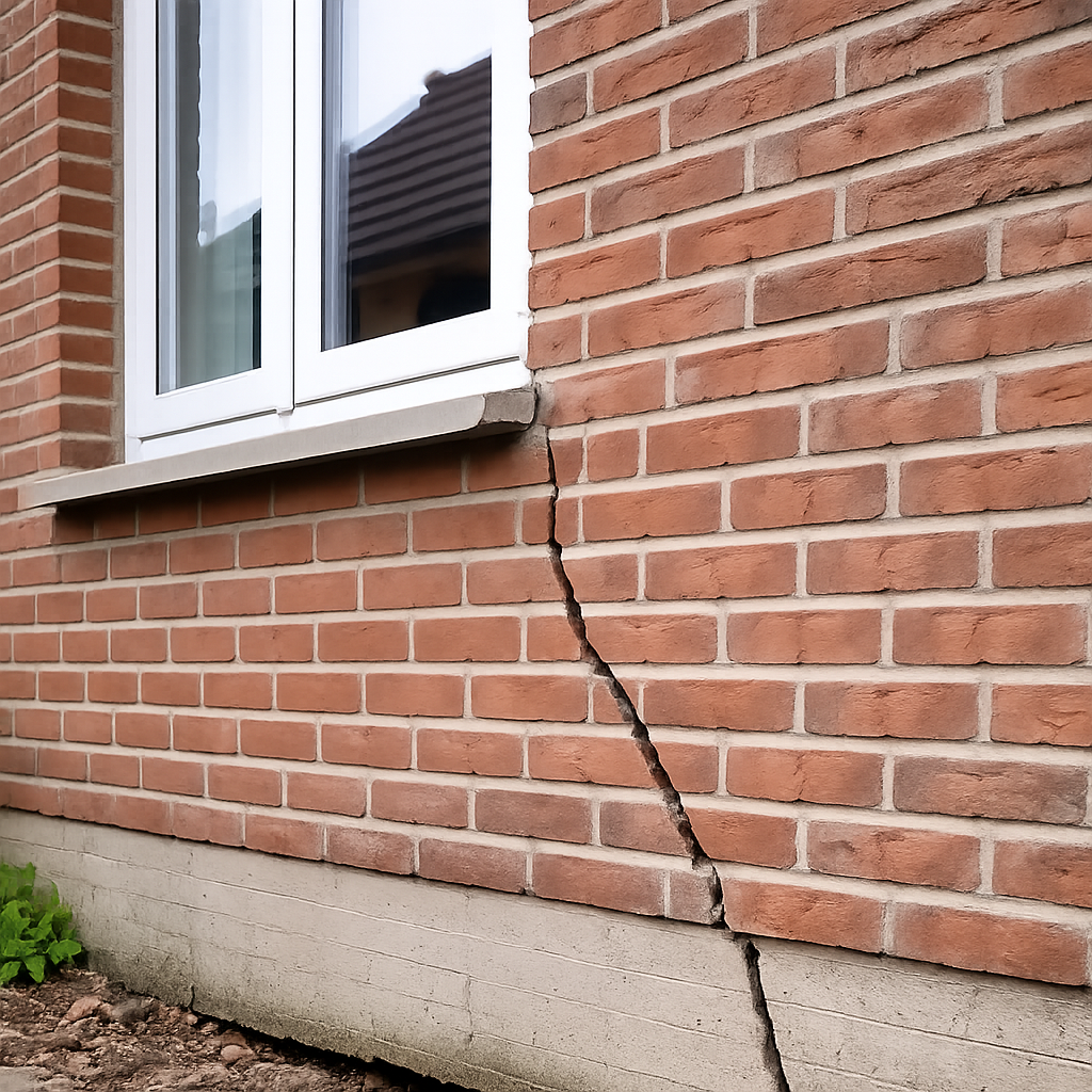
The buildings were provided with tiltmeters and crack width meters. Before placement, the buildings were subjected to a thorough forensic engineering inspection, during which the nature of the damage (mainly cracks) was estimated. The tiltmeters were placed at the edges of the façades, and crack width meters on several characteristic cracks (Figure 3).
Both buildings were constructed around 1890, consist of brick masonry material, and have a shallow foundation (< 1 m). The gross dimensions of the façades of the Ezinge site building is about 20 x 10 m, and that of Ridderkerk 30 x 10 m. The Ezinge building was in recent years on one side extended, but the monitoring is only focused to the original construction. The Ridderkerk building is at the northeast side connected to a neighboring building.
This schematic clearly shows the geological situation underneath this brick building with shallow foundation. A hypothesis is that the building is gradually tilting into the clayey overbank deposits at the northeast corner, whereas the sandy channel deposits at the southwest corner provides more stability. The extensometers were placed at equal depths to quantify deformation of the surficial soft soil relative to the sandy parts. The piezometer filters were placed at the same depth as the anchors, as well as in deeper sandy units to assess vertical groundwater flows, since we expect a strong connection between the lower units of Pleistocene age (below the peat bed) and upper units of Holocene age. Groundwater dynamics in this Pleistocene aquifer might influence shallow soft soil deformation in addition to surficial processes like precipitation or drought.
Results and outlook
The Ezinge site has been operational for over a year now. There, a clear relationship between precipitation (including drought) and movement of the upper expansive salt marsh clay bed is visible (Becerra Silva et al., 2026). Spring 2025 was extremely dry in northwestern Europe; we observed that the surface subsided with ca. 12 mm in 3 months – meaning this area is among the fastest subsiding parts of the country (Fokker et al., 2025). However, the subsidence was largely compensated after intense rain in the subsequent autumn (Figure 5). The building deformation data revealed that the building is mostly responding to seasonal and daily temperature changes, causing the building the expand and contract, visible in the crack width dynamics (Figure 6).
We aim to keep the monitoring sites active for at least five years to capture as much as possible seasonal variations. With that, we are confident that we can unravel the interplay between subsurface deformation and building response. On the long term, we aim to use the monitoring data, combined with ancillary information such soil moisture, for the development of digital twins of the two sites. With these digital twins, we are going to compute full building responses under changing ground conditions. In the long run, such information can be become crucial for mitigation and management strategies.
Acknowledgements
We are indebted to the municipalities Westerkwartier and Ridderkerk for providing us the opportunity to install our monitoring equipment. We would like to thank Museum Wierdenland for their collaboration.
References
Becerra Silva, L.A., Koster, K., Soustelle, V., Teatini, P., Blackman, J., Leeman, J., and Candela, T. (2026). Vertical land motion monitoring of expansive clay with high-precision extensometers in the Groningen coastal plain of the Netherlands. Proc. of the 15th IAEG World Congress IAEG 2026, Delft, the Netherlands. pp. 9
Fokker, P.A., Candela, T., Erkens, G., Hanssen, R.F., Kooi, H., Koster, K., and van Leijen, F.J. (2025). Subsidence. In: Ten Veen, J.H., Vis, G.-J., De Jager, J., and Wong, Th.E. (eds): Geology of the Netherlands, second edition. Amsterdam University Press (Amsterdam). 825-847
RLI, Raad voor de leefomgeving en infrastructuur (2024). Goed gefundeerd: advies om te komen tot een nationale aanpak van funderingsproblematiek (in Dutch). Den Haag, digital edition, pp. 163
TNO-GDN (2026). REGIS II geohydrological model, www.dinoloket.nl/en/subsurface-models/map. Visited 5-6-2026
Veenenbos, J.S. and van Schuylenborgh, J. (1951). The ‘knip’ phenomenon of clay soils. Boor en Spade 4, 24-39

