Industry News
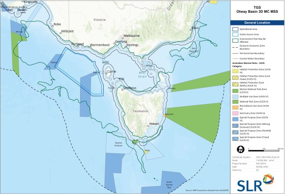
TGS has launched a 3D multi-client marine seismic survey in the Otway Basin in Commonwealth waters offshore from Victoria, and Tasmania, south east Australia. The survey will provide 3D data coverage and improved subsurface imaging to improve understanding of the subsurface, which has been limited to sparse 2D coverage.
The survey area is ~38 km from land at the closest point. Discrete surveys will be acquired within the acquisition area, which covers ~45,000 km2. Water depths within the AA range from 115 m to 5650 m.
The project will also include a ‘tie-in’ to existing geophysical data from previously drilled wells. The 2D tie-line will overlap with 3D data acquisition in the AA. However, it will also extend onto the Continental Shelf and represents a few hours of active source time in shallower waters. At the shallowest point, the tie-line is in a water depth of approximately 115 m and additional control measures will be implemented for this.
A single seismic vessel will tow up to 14 seismic streamers 8-10 km long. The seismic vessel will travel at ~4.5 knots. The acoustic source will either be a ‘dual source’ (comprising two source arrays discharged alternately) or a ‘triple source’ (comprising three source arrays discharged alternately). Each acoustic array will have an effective volume of up to 3480 in3.
The survey is expected to start in October (pending regulatory approval) and will be completed by 30 September 2027. Maximum acquisition time during any calendar year is 200 days with a maximum of 400 days. Based on an analysis of weather and sea state, acquisition is likely to occur from October to March.

Quick Links
Search
Industry News
- Volume 41 | Issue 9 | September 2023

TGS has launched a 3D multi-client marine seismic survey in the Otway Basin in Commonwealth waters offshore from Victoria, and Tasmania, south east Australia. The survey will provide 3D data coverage and improved subsurface imaging to improve understanding of the subsurface, which has been limited to sparse 2D coverage.
The survey area is ~38 km from land at the closest point. Discrete surveys will be acquired within the acquisition area, which covers ~45,000 km2. Water depths within the AA range from 115 m to 5650 m.
The project will also include a ‘tie-in’ to existing geophysical data from previously drilled wells. The 2D tie-line will overlap with 3D data acquisition in the AA. However, it will also extend onto the Continental Shelf and represents a few hours of active source time in shallower waters. At the shallowest point, the tie-line is in a water depth of approximately 115 m and additional control measures will be implemented for this.
A single seismic vessel will tow up to 14 seismic streamers 8-10 km long. The seismic vessel will travel at ~4.5 knots. The acoustic source will either be a ‘dual source’ (comprising two source arrays discharged alternately) or a ‘triple source’ (comprising three source arrays discharged alternately). Each acoustic array will have an effective volume of up to 3480 in3.
The survey is expected to start in October (pending regulatory approval) and will be completed by 30 September 2027. Maximum acquisition time during any calendar year is 200 days with a maximum of 400 days. Based on an analysis of weather and sea state, acquisition is likely to occur from October to March.

