
Tom Davis and Bill Donovan demonstrate how reservoir characterisation techniques have helped to revitalise an oil field in Colorado.
Colorado’s mystery field provides the backdrop for field revitalisation through integrated reservoir characterisation. The following case study illustrates the value of integrated reservoir characterisation in extending the life of a petroleum reservoir. Fractured reservoirs are complex to the point that many have walked away from them as a valued resource. That has changed with the advent of horizontal drilling and integrated reservoir characterisation. In the 1970s the technologies necessary to characterise fractured reservoirs were just beginning to be implemented and our work at Gramps Field provides insights to value creation through integrated reservoir characterisation.
Gramps Field, Colorado
Gramps Field in Southern Colorado, halfway between Pagosa Springs, Colorado and Chama, New Mexico, is referred to as Colorado’s mystery field. The reference is made because the owner of the field did not have to disclose any information about the field to the public. The field was discovered in 1935 during the height of the Great Depression. Its remote location surrounded by the San Juan Volcanic Field made it relatively inaccessible. The field was owned by one individual who operated a ranch in the Banded Peaks portion of the Tierra Amarilla Spanish Land Grant. Forty-two years after the field discovery the challenge presented by the field owner was to see what could be done to extend the life of the field. The fact that Colorado School of Mines played a role throughout the life of the field is testimony to the importance of industry/academia collaboration in value creation.
Gramps Field was first reported by Ingram (1937) as Colorado’s Mystery Field. The land surrounding the field was owned by the Hughes Family who owned and operated a large cattle ranch in the Panhandle of north Texas. During the springtime they would move cattle from Texas to the Banded Peak Ranch in Archuleta County north of Chama, New Mexico. There they would feed them out during the summer and then ship them to market in Denver in the autumn. The ranch in Colorado is comprised of 65,000 acres and is owned by the William E. Hughes Estate. It resides within the boundaries of the Tierra Amarilla land grant that was once owned by the Mexican Government. The discovery of the field is tied to the presence of an oil-seep along the Navajo River 3 miles south of the field reported by Arthur Lakes in 1901. Lakes formed the geology department at Colorado School of Mines (CSM) and the library there is named after him.
In 1934 the Hughes Family hired Walter Waldschmidt, Associate Geology Professor from CSM, to conduct outcrop studies in the hope of finding an oilfield on the ranch. Waldschmidt traversed along the Navajo River from the reported oil seep north toward a tributary called Headache Creek. In doing so he found opposing outcrops dipping first south, then north along the traverse. Plane-table surveying allowed him to project the top of an anticlinal structure just east of the Navajo River within section 24-33N-2E (Figure 1). There the top of the Dakota Sandstone reservoir was discovered by a cable-tool drill rig at a depth of 1080 ft and was completed at 500 bbls/day in December,1935. Drilling the Gramps #2 well took two months to complete by cable tool drilling rig. The discovery well was shut in later that month as storage tanks and facilities did not exist on site and winter settled in. As spring arrived, drilling resumed and by the end of 1936 13 wells had been drilled. Gramps #13 flowed 1920 bbls/day of light oil (Ingram, 1937). With confirmation of a relatively large field discovery, the challenge became how to market the oil from this remote location.
During 1937 a 15-mile-long pipeline was laid over the Continental Divide to Chama, New Mexico, over extremely rugged terrain. The wells were equipped for pumping to fill the pipeline on an as-needed basis with very little storage on site. The pipeline could handle up to 4000 bbls/day. At Chama the oil was loaded onto tank cars and shipped to Alamosa in the San Luis Valley by narrow-gauge railroad. From Alamosa the oil was shipped by the Denver and Rio Grande Railroad to the Continental Oil Company Refinery in Denver until a refinery was built to handle the Gramps Field crude locally in Alamosa. The Oriental Oil Refinery built in 1937 was owned and operated by the Hughes Family (C&TS Dispatch, 2023) until 1965. Oil production through January 1945 was 2,124, 202 bbls (Waldschmidt,1946). As of 1 January, 1969, the field had produced 5,594,400 bbls of oil. Water cut in the field by 1969 was 90%. The average daily production was down to an average of 8bbl/day/well from 22 wells. The projected economic limit of the field was reached in 1977 when water cut averaged 93%. What more could be done to extend the life of the field?
Field rejuvenation
Bill Hughes hired us in 1977 to see what more could be done with seismic and drilling at Gramps Field.
A 2D seismic program was shot during the summers of 1977, ’78 and ‘79 by the Colorado School of Mines Geophysics Department. The first campaign involved shooting a 12-mile line up the axis of the valley along an existing road (Figure 1). The line began at the entrance to Banded Peak Ranch with the valley floor at approximately 8000 ft above sea level (Figure 2). Surrounding peaks of the San Juan Volcanic Field reach up to 12,000 ft above sea level. The floor of the valley involves glacial till with a thickness up to 600 ft. To the north the valley opens up and the Navajo River runs from north to south through the axis of the valley (Figure 3). Natural grassland is plentiful and cattle graze there during the summer under lease by local ranchers. Farther up the valley the forest is logged on an annual basis.
Figure 4 shows William (Bill) E. Hughes, owner of ranch and Gramps Field. Mr Hughes employed approximately 30 people to help him run the ranch. Several worked in the oilfield, while others managed the logging operation and other services. Johnny Miller managed the operation of the oilfield (Figure 5). He was employed by the Hughes family immediately after the Gramps Field discovery was made. He came directly from the East Texas Field as a field hand to Colorado and lived on the Ranch and had a home in Chama, New Mexico. Johnny and Bill formed a friendship that lasted more than 60 years.
Gramps field structure
Figure 6 shows a structure contour map on the top of the Dakota Formation from Waldschmidt (1946). The map was prepared from well control from that time. It shows an asymmetrical anticlinal structure bounded by a singular fault to the north. It also shows the relative position of the Navajo River. The entire field lies within approximately 130 acres, a little less than a quarter section, coloured in red on the map. Of major concern to Bill and Johnny was the potential for contamination of the Navajo River by oilfield operations. This concern was paramount in all the operations they undertook.
A north-south cross-section (Figure 7) shows the Gramps Field stratigraphy and structure. The throw on the bounding fault to the north of the field is approximately 600 ft. To what extent did the fault control the emplacement and entrapment of the oil? The stratigraphic section extends from the Tertiary through the Jurassic and lies unconformably on top of the Precambrian Basement. The Cretaceous Dakota Formation is the main pay section at Gramps Field. The San Juan volcanic cover is young (Miocene to Pliocene) and is associated with the opening of the Rio Grande Rift. The Rio Grande Rift formed in the latter part of the Tertiary, well after the Laramide tectonic event that formed much of the structure in Colorado. The Laramide lasted from 65 million to 40 million years ago. The San Luis Valley, which lies east of the Gramps Field, is the central valley of the Rio Grande Rift and the Rio Grande River runs down the axis of this high mountain valley. The maximum horizontal stress in the region is east-west coinciding with the late opening of the Rio Grande Rift (Davis and Stoughton, 1979).
Seismic interpretation
An eleven mile long, north-south seismic line, traversing Gramps Field is shown in Figure 8. The line was shot in July 1977 with a single vibrator as a source and a 24, 12-string 14 hz geophone spread was shot end-on. The geophone group interval was 220 ft. The vibrating interval was 440 ft and the sweep was an 8-second down-sweep from 58 to 10 hz. Recording was by DFS 10000 recording instruments with a 10-second listen time and sampling rate of 2 ms. Thirty sweeps were conducted at each vibrating point and summed before correlation. The resulting fold was 600% or 6-fold.
Two possible target areas for drilling were highlighted based on the seismic interpretation. The first was on the downthrown side of the east-west fault as illustrated on the seismic line. It was noted that the Dakota seismic signature brightened on the north side of the fault. The implication of this observation is that the fault may be a sealing fault and that the fault may be responsible for the sourcing of oil for Gramps Field.
It was also noted that there were other faults south of the main east-west fault and that the anticlinal structure consists of a series of fault blocks. Potential was noted within two of these blocks for drilling down-structure from the main Gramps Field. In addition to the north-south seismic line, two other short seismic lines were shot 2 miles south of Gramps Field in the vicinity of a projected structural high. The total mileage of the seismic campaign was approximately 20 miles at a cost of approximately $2000/mile.
The W.E. Hughes #1 well was drilled on the bright spot north of the Gramps structure. It was drilled with air until a ‘kick’ occurred from the top of the Greenhorn Formation above the Dakota. It was eventually put on pump at 100 bbls/day from a depth of 1800 ft.
The southern structure was drilled 200 ft higher than an earlier well based on our seismic work but was plugged and abandoned. No further drilling was conducted on the southern structure as no oil-shows occurred even though the structure was confirmed. The problem appeared to be the oil sourcing. Migration pathways associated with faults linked to the eastern ‘kitchen’ took on a whole new perspective after the unsuccessful drilling campaign 2 miles south of the Gramps Field. Previously it was assumed that the oil came from the south from the San Juan Basin.
The main east-west fault is linked to the source of oil in Gramps Field. The fault was interpreted to be a fault zone associated with strike-slip or wrench faulting. Higher heat flow, emanating from depths along this fault zone, facilitated the oil maturation and subsequent migration. The source of the oil is the shale units above the Dakota. These shales exhibit high gamma ray counts indicating thermal maturity of these shales near the fault zone and to the east. The basin east of the field underlying the thick volcanic cover is the likely to be ‘kitchen’ for oil generation and migration. Overpressures also occur in the shales as exhibited by the well kick from the WE#1 well and the associated seismic bright spot.
The WE#1 had already been drilled the previous year, and its success inspired the new seismic and drilling campaign in 1978. During the 1978 seismic campaign more 2D lines were shot on or proximal to the field to characterise the faults and fault blocks associated with the wrench faulting. One such line was shot across the southern portion of the field where minimal field infrastructure existed (Figure 9). A structure contour map on the top of the Dakota Formation was made from well and seismic control (Figure 10). Fault blocks and potential drilling targets were identified. Because of limited access by the terrain and field infrastructure the seismic program involved the acquisition of 4 relatively short seismic lines in the immediate field area with two longer lines in the far northern reaches of the valley. The acquisition parameters used were the same as those of the 1977 campaign. Approximately 25 miles of seismic program were shot during 1978.
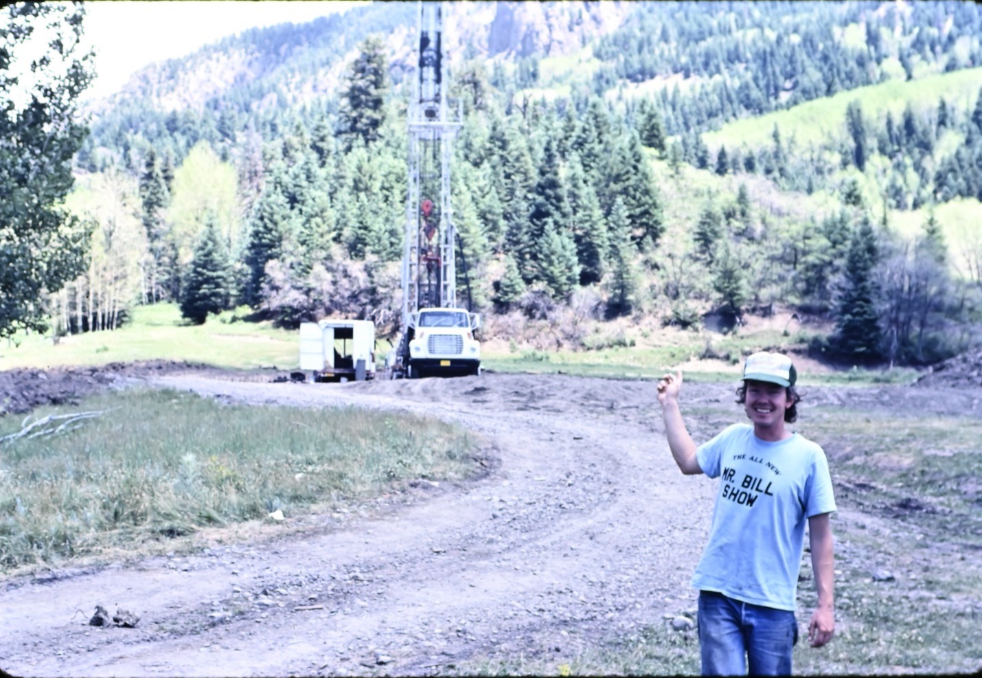
Drilling during the second campaign in 1978 delineated a zone of fractured shale production on the north side of the main field on the down-thrown side of the main east-west fault. Two potential drilling targets were highlighted immediately southwest of the main field area where isolated fault blocks were delineated. A well was drilled in one of these fault blocks and flowed oil with no water for over a year. Water began appearing after a year and the well continued producing oil for over 20 years. The drilling rig is shown in Figure 11 and the pump jack that was subsequently placed on the well is shown in Figure 12. A SP (spontaneous potential) and Resistivity well log through the pay zone is shown in Figure 13. Approximately 160 feet of pay are shown on this log. The average pay thickness in the main Gramps Field is 150 ft. Formation evaluation is difficult in this field as the field is under active water drive and much of the water is fresh.
A fractured reservoir
The wrench fault on the north side of Gramps Field has undergone recurrent movement over time. The youngest movement occurred during the opening of the Rio Grande Rift. That movement caused wrench-related fault block rotation and fracturing of the reservoir at Gramps Field. Several of the wells have large sections of the Dakota reservoir faulted out.
The fact that the seismic programs enabled us to identify several faults that had not been previously recognised suggested that fractures must have played a significant role in this field. High water-oil ratios occur in wells adjacent to some of the faults. Other faults appear to act as sealing faults highlighting the importance of mapping faults and fault blocks in this field. Based on core measurements the average porosity of the Dakota reservoir is 13.6% and the average permeability is 100 md but obviously the total permeability is much higher due to the fractures. The field drive mechanism was characterised as a partially active water drive.
As of early 2000 approximately 9 million bbls of crude oil had been produced from the Gramps Field. Integrated reservoir characterisation in Gramps Field assisted the recovery of an additional 3 million bbls and extended the life of the field by an additional 20 years. The recovery factor in the field was 37%, which is a remarkable achievement.
The field was eventually plugged out and abandoned after a 65-year tenure which was attributed to one man who owned and operated Banded Peak Ranch. He is gone but his legacy lives on. The entrance to the ranch has subsequently been named ‘ATAH II’ (All this and Heaven too). It is a fitting tribute to a legacy based on personal commitment and technical excellence.
Summary
Fractured reservoirs are complex and require integrated reservoir characterisation. Seismic data provide a key to understanding reservoir complexity. What was thought of as a simple anticlinal structure with a single ‘cut-off’ fault to the north turned out to be a complex faulted and fractured series of fault blocks as evidenced by seismic, drilling and production data. The good news is that successful wells were drilled down-structure and extended the life of the field by more than 20 years, adding 3 million barrels of oil production. Gramps Field is an analog for many fractured reservoirs worldwide. There is an adage in the oilfield that a reservoir is at its simplest the day it is discovered and at the most complex the day it is abandoned.
By the early 1980s the average recovery factor from petroleum reservoirs worldwide was 25%. It was clear to see that integrated reservoir characterisation could improve the recovery factor of conventional reservoirs to as much as 40%. Adding carbon dioxide flooding and horizontal drilling has the potential to increase the recovery factor even more. There is another adage from Wallace Pratt that states that ‘Oil is found in the minds of men/women’. Identifying compartmentalisation and fracture networks can reveal new oil in old fields. Only by combining geophysics, geology and petroleum engineering can an operator maximise an asset’s economic life.
The economic value in trying to understand reservoir complexity is that the recovery factor can be increased with integrated reservoir characterisation. Gramps Field later became the impetus for the creation of the Colorado School of Mines industry/academic consortium called the Reservoir Characterization Project (RCP) in 1984 (Davis, 2025). RCP lives on because the more we understand the reservoir through integrated reservoir characterisation the more we can extract from it economically.
Acknowledgement
The authors would like to thank Sue Jackson for reviewing this paper on our behalf. It is often difficult as an author to put yourself in the reader’s shoes.
References
- C&TS (Cumbres and Toltec Scenic Railroad). [2023] Dispatch, 36(1), p.1-23.
- Davis, T. [2025] Colorado School of Mines’ Reservoir Characterization Project celebrates 40 years with important lessons to share: First Break, 43(4), p. 39-42.
- Davis, T.L. and Stoughton, D. [1979] Interpretation of seismic data from the northern San Luis Valley, South-Central Colorado. In Reiker, R.F., ed, Rio Grande Rift Tectonics and Magmatism. American Geophysical Union, p.185-194.
- Donovan, W. [1978] Price Gramps Field: Four Corners Geological Society, Oil and Gas Fields of the Four Corners Area, p.157-159.
- Ingram, T.R. [1937] Colorado’s “Mystery” Field. Mines Magazine, 27(5), p.32-33.
- Waldschmidt, W.A. [1946] Gramps Field, Archuleta County, Colorado. American Association of Petroleum Geologists Bull., 30(4), p.561- 580.

