
The Blötberget iron-oxide-apatite (IOA) deposits in central Sweden have evolved into one of Europe’s best-characterised hardrock geophysical test sites through more than a decade of integrated research and technology development. By combining physical properties characterisation, reflection seismics, broadband acquisition, sparse 3D imaging and emerging sensing technologies, geological uncertainty was progressively reduced, ultimately leading to successful deep drilling of previously untested seismic targets. The study demonstrates how integrated geophysics can effectively de-risk mineral exploration and improve confidence in deep targeting.
Introduction
The search for new mineral deposits is entering a new era. Many of the easily discoverable deposits have already been found, leaving exploration geologists increasingly challenged to identify deposits concealed beneath hundreds of metres of cover or located at depths beyond the reach of conventional exploration techniques. At the same time, the global transition towards reduced emissions of carbon dioxide, electrification and renewable energy has dramatically increased demand for high-grade iron, copper, graphite, phosphorous, tungsten, rare earth elements (REEs) and other critical raw materials. The exploration industry therefore faces a dual challenge: (1) discovering deeper deposits while doing so in (2) a cost-effective, environmentally responsible and technically reliable manner.
Unlike petroleum exploration, where 3D seismic imaging has become a routine exploration tool, the application of reflection seismics in hardrock mineral exploration remains comparatively young (e.g., Malehmir et al., 2012 and references therein). Complex geology, steeply dipping structures, heterogeneous rock properties and difficult near-surface conditions have traditionally limited its widespread adoption (Eaton et al., 2003 and references therein). Yet these are precisely the environments where seismic methods have the greatest potential to reduce geological uncertainty.
Over the past decade, the Blötberget iron-oxide-apatite (IOA) deposits (Figure 1) in the historic Bergslagen mining district of central Sweden have become an ideal natural laboratory for testing this idea. Rather than relying on a single geophysical method or one exploration campaign, the site has evolved through a series of increasingly sophisticated investigations, each designed to answer geological questions left unresolved by the previous study. Beginning with detailed petrophysical characterisation and pilot seismic profiling, the work expanded to include UAV magnetic surveys (Malehmir et al., 2017a), sparse 3D seismic acquisition (Malehmir et al., 2021), broadband seismic sources (Pertuz et al., 2022, Gyger et al., 2025a), borehole physical properties measurements (Maries et al., 2017), distributed acoustic sensing (DAS; Gyger et al., 2025b), ambient-noise imaging (Wilczynski et al., 2025) and multi-component seismic experiments (Markovic et al., 2025). Together, these studies transformed isolated geophysical observations into an integrated geological understanding that ultimately justified drilling entirely new deep exploration targets.
This article tells the story of that journey. It demonstrates how innovation in acquisition technologies, advances in imaging and interpretation, and close collaboration between academia, industry and technology developers progressively reduced exploration uncertainty. More importantly, it illustrates that successful deep targeting is rarely achieved through a single breakthrough. Instead, confidence develops incrementally as independent datasets converge towards a consistent geological model capable of supporting high-cost drilling decisions.
De-risking deep drilling
One of the most important lessons learnt throughout this programme is that mineral exploration should not be viewed simply as the search for geophysical anomalies. A strong anomaly may be intriguing, but unless it can be explained within a robust geological framework, it remains a risky drilling target. Instead, our strategy focused on progressively reducing geological uncertainty and de-risking deep targeting. Every new survey was designed to answer a specific question while simultaneously identifying the next set of unknowns. Early downhole physical properties measurements (Figure 2; Maries et al., 2017) established whether seismic methods were likely to be effective. Pilot seismic surveys evaluated acquisition concepts (e.g., Malehmir et al., 2017b; Markovic et al., 2020). 2D reflection seismics improved structural understanding but also highlighted ambiguities associated with out-of-plane reflections. These observations motivated the acquisition of Sweden’s first sparse 3D reflection seismic survey for mineral exploration (Malehmir et al., 2021), which in turn revealed new structural features and possible extensions of the known mineralisation. More recent experiments using broadband seismic sources, fibre-optic sensing and passive seismic techniques continue to refine this geological model while providing valuable insights into the capabilities of emerging exploration technologies.
This iterative approach fundamentally differs from traditional exploration workflows in which individual surveys are often treated as independent investigations. At Blötberget, every experiment became part of a larger scientific and exploration strategy. Success was measured not only by improved images but also by how much each dataset reduced uncertainty and increased confidence in subsequent decisions. Today, the site represents far more than an iron-oxide deposit. It serves as a full-scale outdoor laboratory where new sensing technologies, acquisition systems, imaging algorithms and interpretation workflows can be evaluated under realistic exploration conditions. This philosophy has attracted numerous national and international research collaborations and has helped to transform Blötberget into one of the most comprehensively studied hardrock geophysical test sites in Europe. The new Smart Exploration Research Center initiative (Malehmir et al., 2024) has its focus in this region to broaden the scope towards more geological and mineralogical studies (e.g., Andersson et al., 2026; Dunst et al., 2026; Kelemen et al., 2025).
Knowing the rocks before imaging them
Understanding the physical properties of the subsurface is a fundamental prerequisite for designing an effective geophysical survey. These properties provide the basis for selecting appropriate exploration methods, optimising acquisition parameters and assessing whether the expected geological targets are likely to generate detectable geophysical responses.
At Blötberget, the first step was therefore not to acquire more seismic data but to establish a comprehensive physical properties framework. Historical exploration drilling provided an excellent opportunity to investigate the elastic and physical properties of both the iron-oxide mineralisation and the surrounding host rocks. Beginning in 2015, a series of boreholes were downhole logged using full-waveform sonic tools together with natural gamma, density, magnetic susceptibility, electrical resistivity, fluid conductivity and temperature measurements. Core samples were also systematically analysed for density and magnetic properties (Almqvist et al., 2019). The results demonstrated why reflection seismic deserved particular attention. Magnetite- and hematite-rich mineralisation possess significantly higher acoustic impedance than the surrounding felsic volcanic and metavolcanic host rocks. One-dimensional synthetic seismograms generated from the borehole measurements predicted strong reflections from the mineralised horizons, suggesting that the deposits should be readily detectable even at considerable depth (Figure 2). The modelling also showed that multiple closely spaced mineral-bearing lenses would generate characteristic reflection packages rather than isolated seismic events, an observation that later became invaluable during seismic interpretation.
These properties also helped to define the limitations of alternative exploration methods. Although the iron-oxides exhibit relatively low electrical resistivities compared with the surrounding rocks, the expected depth of the targets and the complexity of the geological setting reduce the effectiveness of conventional electrical and electromagnetic techniques for imaging their full geometry. Magnetic surveys remain extremely valuable for mapping regional structures and near-surface mineralisation, but magnetic inversion alone cannot uniquely resolve the depth, thickness or dip of steeply inclined ore bodies. Reflection seismic, on the other hand, offered the possibility of directly imaging geological boundaries while simultaneously providing information on the structural framework controlling mineralisation.
This early investment in physical properties analysis fundamentally influenced every subsequent exploration decision. Rather than selecting seismics because it was a novel technology, the choice was guided by measurable rock properties and quantitative forward modelling. In many respects, the downhole measurements became the bridge between geology and geophysics, allowing acquisition parameters, processing strategies and interpretation workflows to be designed around realistic expectations of the subsurface response.
A simple experiment with an important lesson
Having established that the mineralisation should produce a strong seismic response, the next question was straightforward: could a relatively inexpensive seismic survey image the deposits at exploration depths?
At the time, landstreamer systems had demonstrated considerable success for shallow engineering and environmental investigations, but their potential for hardrock mineral exploration remained largely unexplored. Conventional wisdom suggested that imaging targets approaching one-kilometre depth would require large seismic sources, extensive receiver arrays and expensive acquisition campaigns. We decided to challenge that assumption.
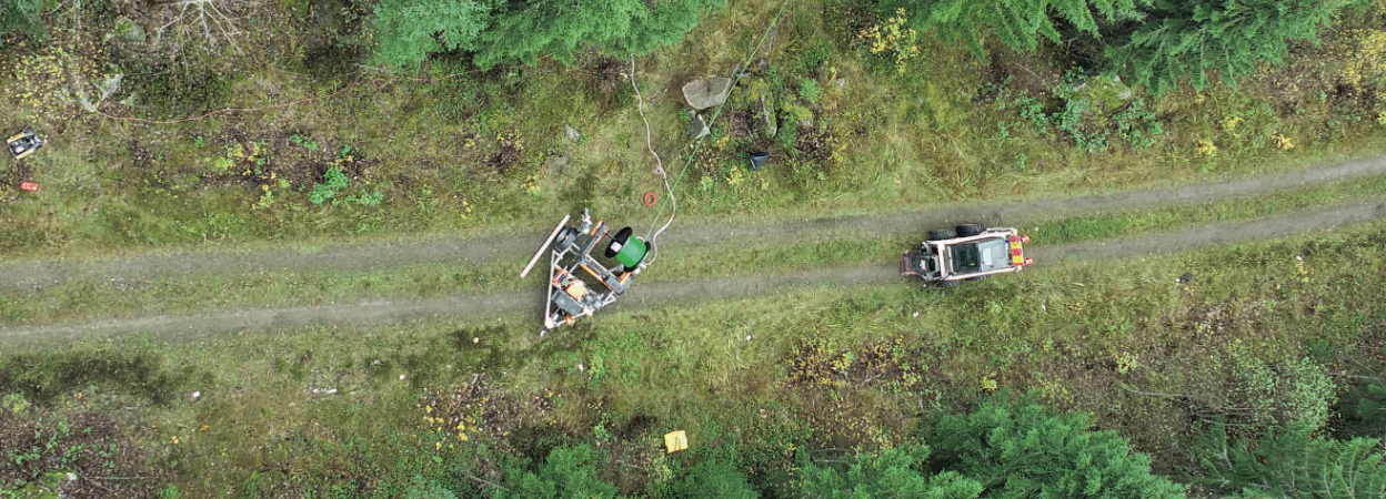
In 2015, a pilot reflection seismic survey was designed around a 240m-long MEMS-based landstreamer equipped with one hundred sensors spaced at 2-4 m intervals (Malehmir et al., 2017b). To complement the moving streamer, wireless seismic stations were deployed at wider spacing, while a commercially available 500 kg Bobcat-mounted drophammer served as the seismic source (Figure 3a,b). The survey covered approximately 3.5 km of profile in only a few days, demonstrating that rapid, relatively low-cost acquisition was possible even within an active mining environment. The processed seismic section revealed a distinct package of high-amplitude reflections coinciding remarkably well with the known iron-oxide mineralisation intersected by existing boreholes. Even more encouraging was the observation that these reflections appeared to continue beyond the deepest drilling, suggesting that the deposits extended farther down dip than previously recognised. Although the survey itself did not immediately redefine the geological model, it provided the first convincing evidence that reflection seismic could successfully image steeply dipping iron-oxide bodies in the crystalline rocks of Bergslagen (central Sweden).
Perhaps the most important lesson, however, was not the quality of the image itself but the questions it generated. Were the reflections continuous beyond the known mineralisation? Could some events represent out-of-plane reflections from adjacent ore lenses? How did major faults influence the seismic response? These uncertainties could not be resolved from a single two-dimensional profile alone. Rather than providing final answers, the pilot survey laid the foundation for the next phase of investigation, ultimately leading to orthogonal 2D surveys, broadband acquisition and Sweden’s first sparse 3D reflection seismic survey dedicated to mineral exploration.
To address these challenges, two orthogonal seismic profiles were acquired using conventional exploration equipment and processed together with the earlier landstreamer data. The combined datasets significantly improved the continuity of the interpreted reflections and extended reliable imaging of the mineralisation from approximately 800 m to nearly 1.2 km depth (Markovic et al., 2020). More importantly, the intersecting profiles provided the first 3D perspective of the structural framework, revealing several fault systems that appeared to offset or truncate the mineralised horizons. These observations highlighted the importance of understanding the structural architecture controlling the deposits rather than simply delineating individual ore lenses. The success of the 2D surveys naturally motivated the next step: acquiring a 3D seismic dataset capable of resolving the complex geometry of the mineralised system.
From 2D to 3D geological understanding
By 2019, sufficient geological and geophysical information had been accumulated to justify Sweden’s first sparse 3D reflection seismic survey designed specifically for mineral exploration. Rather than maximising fold through dense acquisition, the survey was optimised around existing forest roads and tracks to minimise environmental impact while maintaining adequate subsurface illumination. Approximately 1200 receivers and more than 1000 vibrator source locations (Figure 3c) were deployed across an area of about 6 km², providing an efficient compromise between acquisition cost and imaging quality. The transition from 2D to 3D imaging fundamentally changed the geological interpretation. Events that previously appeared discontinuous or ambiguous could now be traced between profiles, allowing the mineralised horizons and associated structures to be interpreted with substantially greater confidence (Figure 4). The seismic volume confirmed that the known deposits continue down dip beyond existing drilling and revealed additional reflective bodies laterally adjacent to the currently defined resources. Amplitude-supported interpretation, integrated with borehole information and petrophysical constraints, suggested the presence of previously unrecognised iron-oxide mineralisation that could represent a significant addition to the resource base.
Equally important was the improved characterisation of the structural framework. Several steep faults were identified cutting through both the host rocks and the mineralised sequence, providing new insights into the tectonic evolution of the deposit and the possible controls on mineral emplacement. These structures also helped to explain local variations in seismic reflectivity and highlighted the importance of structural complexity when planning future drilling campaigns.
The 3D model subsequently became the foundation for integrating additional geological and geophysical datasets, including gravity modelling, magnetic inversion, borehole information and more recent broadband seismic experiments. Rather than replacing previous interpretations, the 3D seismic survey provided the spatial framework within which all subsequent observations could be evaluated consistently. It also transformed the exploration strategy from mapping known mineralisation to testing new geological hypotheses regarding the continuity and structural controls of the deposit.
Beyond conventional reflection seismics
The success of the sparse 3D seismic survey did not mark the end of the exploration programme. On the contrary, it highlighted new scientific and technical questions that could not be fully addressed using conventional seismic acquisition alone. While the geometry of the principal mineralised horizons had become significantly clearer, further improvements were needed in imaging steep fault systems, characterising the near surface, increasing spatial resolution and evaluating emerging sensing technologies that may shape the future of mineral exploration.
One of the first developments was the introduction of broadband seismic sources. Conventional Vibroseis sources typically operate over a limited frequency range, restricting either penetration depth or spatial resolution. To investigate whether broader frequency content could improve imaging of complex hardrock geology, an electrically driven broadband seismic vibrator (Figure 3d) capable of generating sweeps between approximately 2 and 200 Hz was tested along the original exploration profile (Pertuz et al., 2021). The broader bandwidth produced noticeably sharper reflections and significantly improved imaging of several fault zones intersecting the iron-oxide deposits (Figure 4b). The study also demonstrated that advances in source technology can provide tangible geological benefits rather than simply improving seismic bandwidth.
From interpretation to drilling decisions
Final objective of any exploration programme is not simply to acquire high-quality geophysical images but to support informed drilling decisions. Drilling remains the most expensive and definitive stage of mineral exploration, and every exploration campaign should therefore contribute to reducing the uncertainty associated with selecting drill targets.
At Blötberget, confidence in the deep exploration targets developed progressively over nearly a decade. This integrated understanding justified a new deep drilling programme designed in 2025 in a collaborative effort within the Smart Exploration Research Center (Nordic Iron Ore, 2025), to test the interpreted continuation of the mineralisation and evaluate the structural framework controlling the deposits (Figure 5). Importantly, the drillholes were not positioned simply to intersect isolated seismic amplitudes. Instead, they were planned to test a comprehensive geological model developed through the integration of reflection seismic data, borehole information, petrophysical measurements and structural interpretation. Such an approach substantially reduces exploration risk and maximises the geological value of every drilled metre. Two boreholes were initially planned, BH1 and BH2 (Figure 5). Their naming changed later during the drilling campaign as we present below.
Discovery borehole
BB25-001, or planned BH1, was the first borehole drilled in 2025. It intersected mineralisation at 1044-1052 m as well as 1063-1074 m borehole depth (Figure 6). The intersection was primarily of hematite and estimated to contain 40-65% iron content, which was considered a remarkable discovery also suggesting that the interpretation of a depth extension was right and the seismic method could be used for drill selection and de-risking drilling (Nordic Iron Ore, 2026). Prior to drilling BH2 or BB25-019, new boreholes were chosen to test various elements of reflectivity in the 3D volume. In particular, BB25- 013 test a small folding structure west of the 3D volume. This borehole also intersected the mineralisation at about 800 m depth. BB25-019 intersected several zones of weaknesses and at a depth of around 700 m suggesting an extensive fault system is possible in this part of the seismic cube.
Follow-up physical properties
Follow-up physical property measurements were carried out on core samples from several boreholes drilled in 2025, including the recently drilled discovery hole BB25-001, to better constrain the origin of the observed seismic reflectivity. Bulk density and ultrasonic P-wave velocity measurements reveal a clear separation between the host rocks and the iron-oxide mineralisation (Figure 7). While the hanging-wall and footwall rocks generally exhibit densities of 2600-3000 kg/m³ and P-wave velocities of 4100–5300 m/s, the magnetite- and hematite-rich ore samples are characterised by substantially higher densities (4000-5100 kg/m³) and velocities of approximately 4800-6000 m/s. This pronounced acoustic impedance contrast (density × velocity) explains the strong seismic reflections observed throughout the surveys and confirms that density, more than seismic velocity alone, is the dominant contributor to the reflectivity of the ore bodies. The measurements also indicate that variations in mineral composition, particularly the relative abundance of magnetite and hematite, influence the reflection strength, with the densest magnetite-rich intervals expected to generate the highest reflection amplitudes.
Conclusions
The Blötberget project illustrates how long-term integration of geology, petrophysics and geophysics can progressively reduce exploration uncertainty and support confident deep drilling decisions. Rather than relying on a single exploration technique, the programme combined laboratory measurements, downhole logging, pilot seismic surveys, conventional and sparse 3D reflection seismics, broadband acquisition and emerging sensing technologies into a unified exploration strategy. Each investigation addressed specific geological questions while providing the foundation for subsequent surveys, ultimately transforming isolated geophysical observations into a robust three-dimensional geological model.
The successful intersection of mineralisation in the 2025 discovery borehole BB25-001 and subsequent drilling demonstrated that the interpreted seismic targets represented genuine geological features rather than isolated geophysical anomalies. Follow-up drilling and new physical property measurements further confirmed that the pronounced acoustic impedance contrast between the iron-oxide mineralisation and its host rocks is responsible for the strong seismic reflectivity observed throughout the study area, reinforcing confidence in reflection seismic as an effective method for deep targeting in crystalline environments.
Perhaps the most important outcome extends beyond Blötberget itself. The study demonstrates that successful deep exploration is an iterative process in which geological understanding, technological innovation and exploration decisions evolve together. Reflection seismic imaging played a central role, but its greatest value emerged through integration with complementary datasets and continuous validation by drilling. Establishing Blötberget as an open hardrock geophysical test site has also created a unique environment for developing and evaluating next-generation exploration technologies in close collaboration between academia, equipment developers and the mining industry.
As the global demand for critical raw materials continues to grow and exploration targets become progressively deeper and more structurally complex, future discoveries will increasingly depend on integrated, multidisciplinary exploration strategies rather than individual geophysical methods. The experience gained at Blötberget demonstrates that investing in systematic uncertainty reduction, rigorous geological calibration and collaborative technology development can substantially improve exploration success while reducing the technical and financial risks associated with deep drilling. In this respect, the journey from geophysical anomaly to validated drill target offers a practical blueprint for the next generation of mineral exploration.
Acknowledgements
This work is partly supported by the Smart Exploration Research Centre (SERC). The centre, www.smartexploration. se, has received funding from the Swedish Foundation for Strategic Research (SSF) under grant agreement no. CMM22- 0005. We gratefully acknowledge Epiroc for its expert support in the planning and execution of the drilling campaign. This is publication number: SE26-051.
References
- Almqvist, B.S., Björk, A., Mattsson, H.B., Hedlund, D., Gunnarsson, K., Malehmir, A., Högdahl, K., Bäckström, E. and Marsden, P. [2019] Magnetic characterisation of magnetite and hematite from the Blötberget apatite–iron oxide deposits (Bergslagen), south-central Sweden. Canadian Journal of Earth Sciences, 56(9), 948-957.
- Andersson, S.S., Jonsson, E., Zack, T., Rösel, D., Holtstam, D. and Sadeghi, M. [2026] Timing and evolution of REE-Fe-polymetallic skarn mineralisation in the REE-line, Bergslagen, Sweden: insights from molybdenite Re-Os geochronology, petrographic-paragenetic relationships and trace element chemistry. Mineralium Deposita, 1-30.
- Dunst, R., Pitcairn, I., Jansson, N.F., Lewerentz, A., Karlsson, A. and Liu, X. [2026] Element mobility during regional hydrothermal sodium and magnesium alteration: implications for ore formation in the Bergslagen ore district, Sweden. Mineralium Deposita, 61(3), 551-576.
- Eaton, D.W., Milkereit, B. and Salisbury, M.H. [2003] Hardrock seismic exploration. Society of Exploration Geophysicists.
- Gyger, L., Malehmir, A., Manzi, M., Vivin, L., Lépine, J., Kaslilar, A., Valishin, O., Marsden, P. and Hamerslag, R. [2025a] Broadband seismic data acquisition and processing of iron-oxide deposits in Blötberget, Sweden. Geophysical Prospecting, 73, 80-95.
- Gyger, L., Malehmir, A., Manzi, M., Valishin, O. and Hamerslag, R. [2025b] Surface distributed acoustic sensing for mineral exploration. Scientific Reports, 15(1), 43391.
- Kelemen, P., Zack, T., Rösel, D., Dunkl, I. and Lynch, E.P. [2025] Tracing the Thermal History of critical raw material deposits in Bergslagen, Sweden: Insights from high-and low-T thermochronology. Proceedings of Goldschmidt 2025 Conference.
- Malehmir, A., Durrheim, R., Bellefleur, G., Urosevic, M., Juhlin, C., White, D.J., Milkereit, B. and Campbell, G. [2012] Seismic methods in mineral exploration and mine planning: A general overview of past and present case histories and a look into the future. Geophysics, 77(5), WC173-WC190.
- Malehmir, A., Dynesius, L., Paulusson, K., Paulusson, A., Johansson, H., Bastani, M., Wedmark, M. and Marsden, P. [2017a] The potential of rotary-wing UAV-based magnetic surveys for mineral exploration: A case study from central Sweden. The Leading Edge, 36, 552-557.
- Malehmir, A., Maries, G., Bäckström, E., Schön, M. and Marsden, P. [2017b] Developing cost-effective seismic mineral exploration methods using a landstreamer and a drophammer. Nature Scientific Reports, 7, 10325.
- Malehmir, A., Markovic, M., Marsden, P., Gil, A., Buske, S., Sito, L., Bäckström, E., Sadeghi, M. and Luth, S. [2021] Sparse 3D reflection seismic survey for deep-targeting iron oxide deposits and their host rocks, Ludvika Mines, Sweden. Solid Earth, 12, 483-502.
- Malehmir, A., Markovic, M., Papadopoulou, M., Högdahl, K., Ask, M., Strømme, M., Pitcairn, I., Martin, T., Zack, T., Majka, J. and Svensson, M. [2024] Smart Exploration Research Centre: Knowledge and innovation for exploration of critical raw materials. First Break, 42(8), 89-93.
- Maries, G., Malehmir, A., Bäckström, E., Schön, M., and Marsden, P. [2017] Downhole physical property logging for iron-oxide exploration, rock quality, and mining: An example from central Sweden. Ore Geology Reviews, 90, 1-13.
- Markovic, M., Maries, G., Malehmir, A., von Ketelholdt, J., Bäckström, E., Schön, M., and Marsden, P. [2020] Deep reflection seismic imaging of iron-oxide deposits in the Ludvika mining area of central Sweden. Geophysical Prospecting, 68, 7-23.
- Markovic, M., Malehmir, R. and Malehmir, A. [2022] Diffraction pattern recognition using deep semantic segmentation. Near Surface Geophysics, 20(5), 507-518.
- Markovic, M., Malehmir, A., Manzi, M.S.D. and Hamerslag, R. [2025] Feasibility of multicomponent reflection seismic imaging for direct targeting of metallic mineral deposits. Geophysics, 90(6), B357- B366.
- Nordic Iron Ore AB. [2025] Deep drilling has encountered promising iron-oxide mineralization. Press release, 18 March. Available here (Accessed: 17 July 2026).
- Nordic Iron Ore AB. [2026] Nordic Iron completes drilling in Blötberget with several promising intersections and strong potential for increased mineral resources. Press release, 18 February. Available here (Accessed: 17 July 2026).
- Pertuz, T., Malehmir, A., Bos, J., Brodic, B., Ding, Y., de Kunder, R. and Marsden, P. [2022] Broadband seismic source data acquisition and processing to delineate iron oxide deposits in the Blötberget mine-central Sweden. Geophysical Prospecting, 70, 79-94.
- Wilczynski, Z., Kaslilar, A., Malehmir, A., Manzi, M., Vivin, L., Lépine, J. and Valishin, O. [2025] Ambient noise surface-wave imaging in a hardrock environment: implications for mineral exploration. Geophysical Journal International, 240, 571-590.

